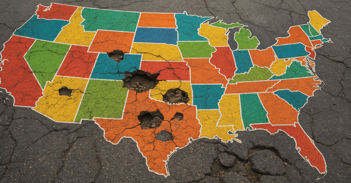
Discover The Wild Places That States In The USA
Across the country, dramatic formations rise, plunge, glow, echo, or twist in ways that rarely repeat themselves. Every state adds its own signature natural scene, each shaped by forces far older than the towns built beside them.

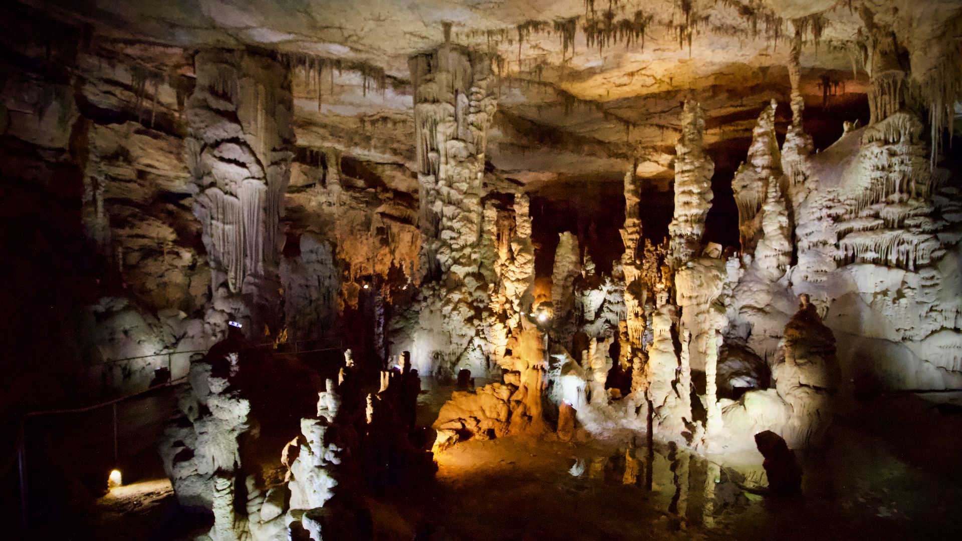
Alabama's Cathedral Caverns
Rising at an entrance measuring 126 feet across and up to 60 feet high, Cathedral Caverns offers one of the world’s largest natural cave openings. Inside, Goliath towers 45 feet tall among extensive stalactites and stalagmites to form Alabama’s most iconic cave system.
 Diegoandrade, Wikimedia Commons
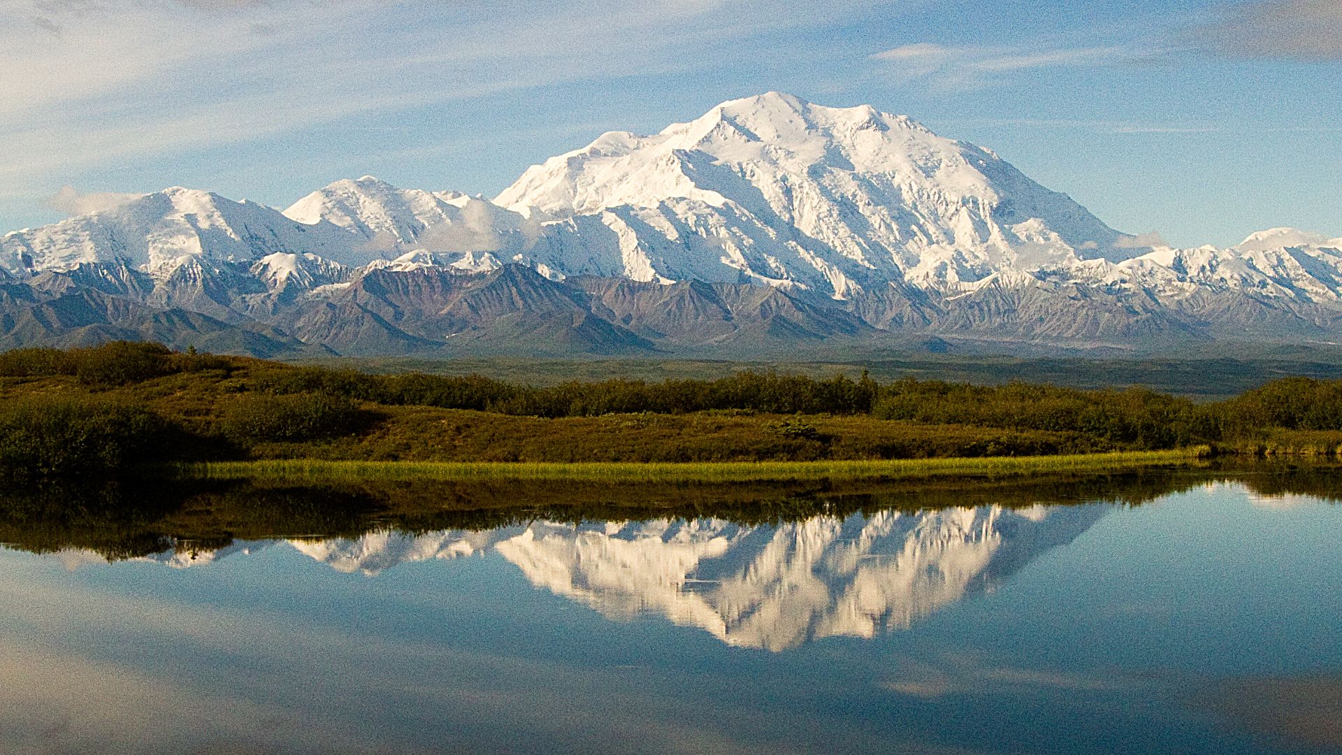
Alaska's Denali
At 20,310 feet, Denali dominates more than six million acres of protected wilderness. Glaciers and roaming wildlife, including grizzly bears, wolves, moose, and caribou, surround North America’s tallest peak, creating Alaska’s defining natural wonder and the dramatic centerpiece of Denali National Park.
 Denali National Park and Preserve, Wikimedia Commons
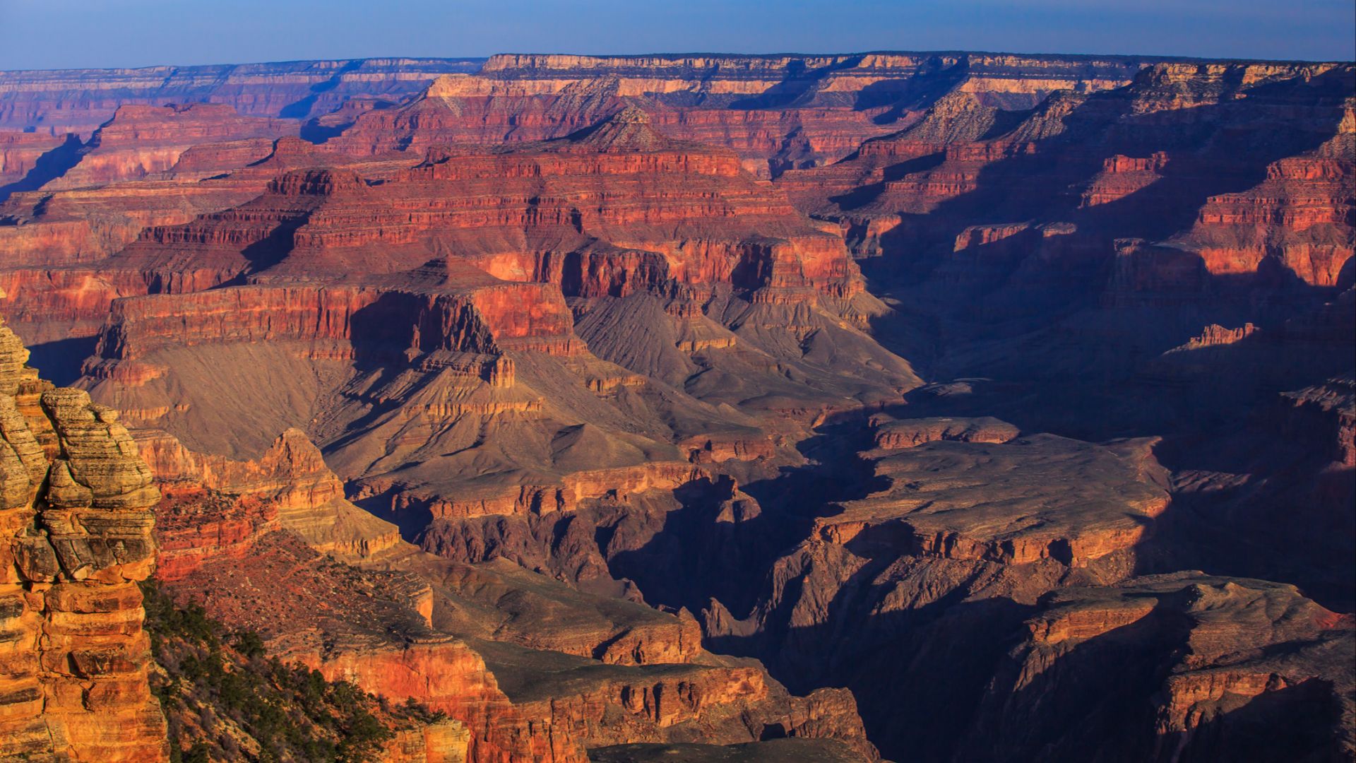
Arizona's Grand Canyon
Almost 277 miles long, 18 miles wide, and a mile deep, the Grand Canyon reveals close to two billion years of exposed geological history. Carved by the Colorado River over millions of years, this UNESCO World Heritage Site draws millions annually.
 Murray Foubister, Wikimedia Commons
Arkansas's Blanchard Springs Caverns
Within the Ozarks, Blanchard Springs Caverns displays extensive stalactites and stalagmites highlighted along the Dripstone Trail. This living cave system reflects a prominent underground landscape and contrasts with famous sites like Mammoth Cave. The site shows the state’s own naturally formed chambers carved through centuries of geological activity.

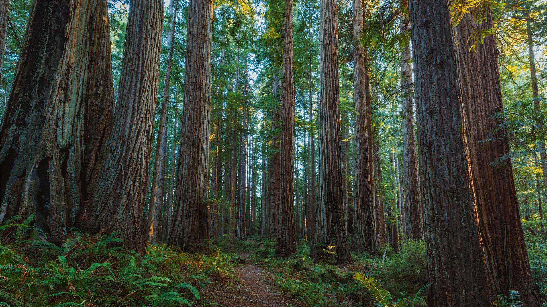
California's Redwood Forest National And State Parks
Home to the tallest trees on our planet, Redwood National and State Parks protect old-growth forests where redwoods soar up to 379 feet and can live for two thousand years. Coastal fog sustains these giant trees across more than 130,000 acres of preserved California wilderness and rugged Pacific coastline.
 California Department of Parks and Recreation, Wikimedia Commons
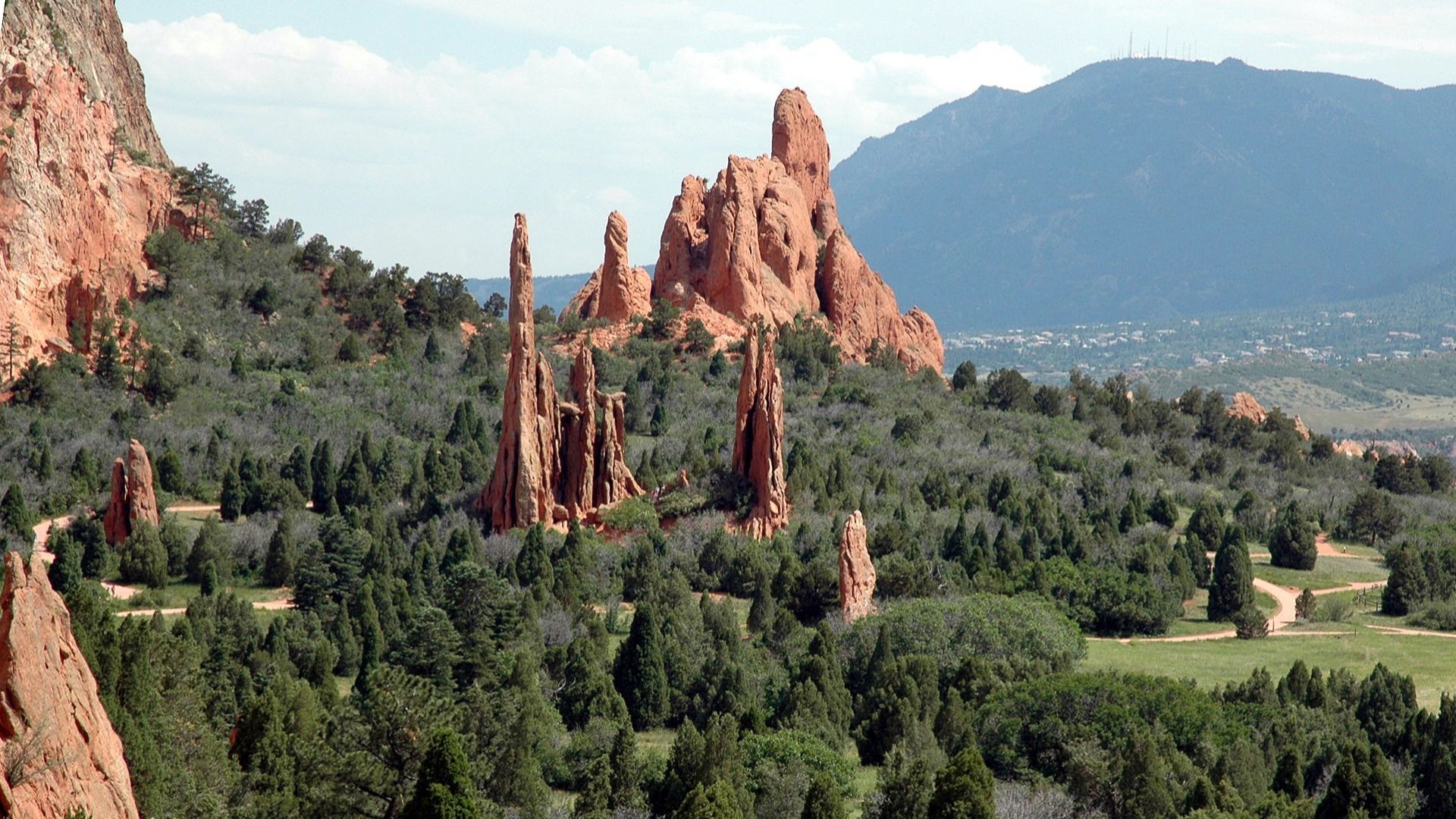
Colorado's Garden Of The Gods
Centered near Colorado Springs, Garden of the Gods spans 1,300 acres marked by soaring red sandstone and limestone formations shaped over millions of years. Peaks rising more than 300 feet define Colorado’s signature landscape to secure the spot’s position as the state’s most celebrated natural wonder and a striking geological landmark.
 Robert Corby (User:Corbyrobert), Wikimedia Commons
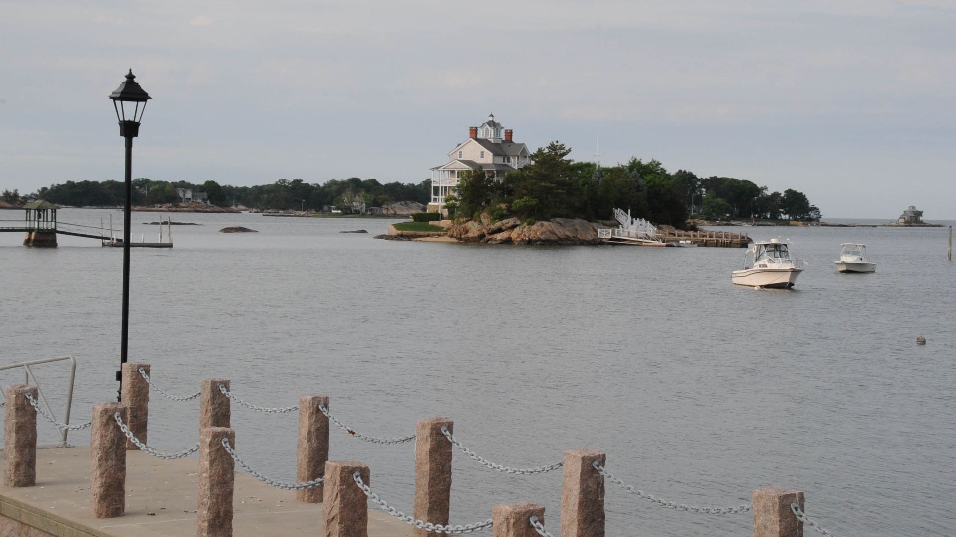
Connecticut's Thimble Islands
Scattered across Long Island Sound, the Thimble Islands form a granite-based archipelago shaped by glacial movement during the last ice age. Their rocky shorelines and marine habitats create one of Connecticut’s most distinctive coastal environments and a favored destination for boating and wildlife viewing.
 JERRYE & ROY KLOTZ, M.D., Wikimedia Commons
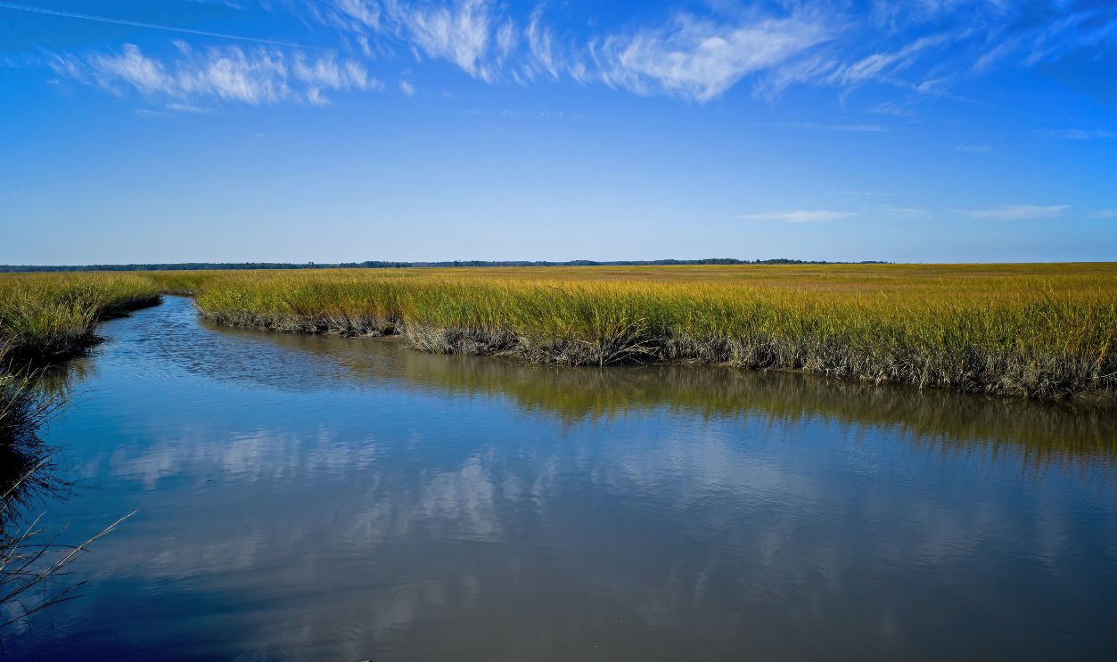
Delaware's Coastal Salt Marshes
Across Delaware Bay, broad salt marshes support one of North America’s most productive ecological systems. Millions of migratory shorebirds stop here during seasonal flights, relying on wetlands that also nurture blue crabs and other valuable species. Sites such as Bombay Hook highlight this globally significant migration corridor.
 Michael G McKinne, Shutterstock
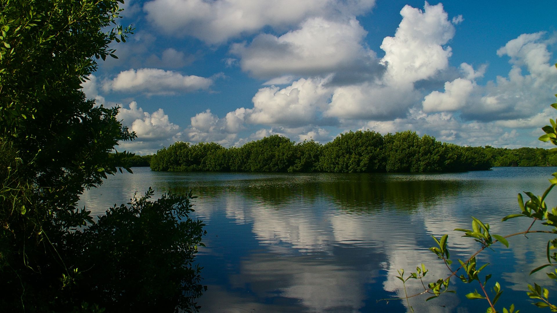
Florida's Everglades National Park
Flowing across 1.5 million acres, the Everglades forms a sweeping subtropical wetland marked by sawgrass marshes, mangroves, cypress swamps, and intricate waterways. Endangered wildlife, including the Florida panther and manatee, depend on this vast ecosystem.
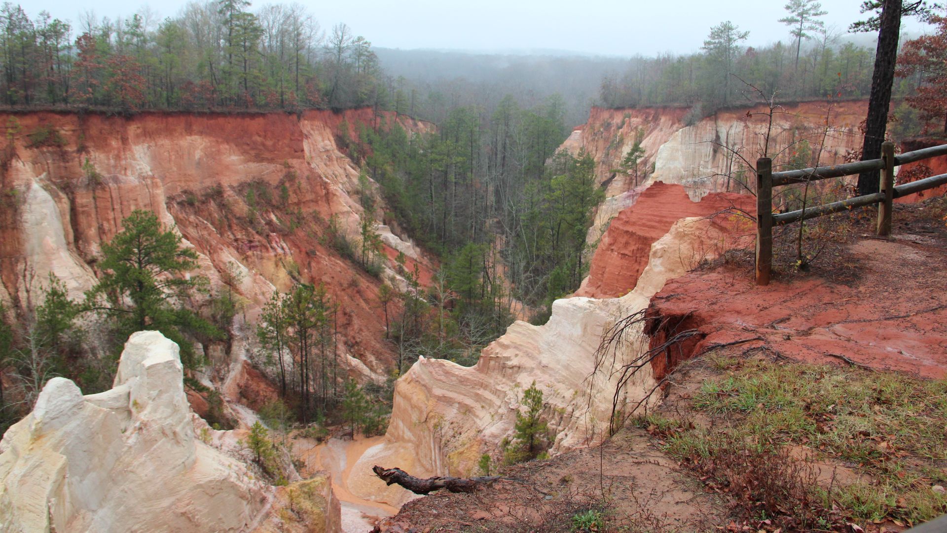
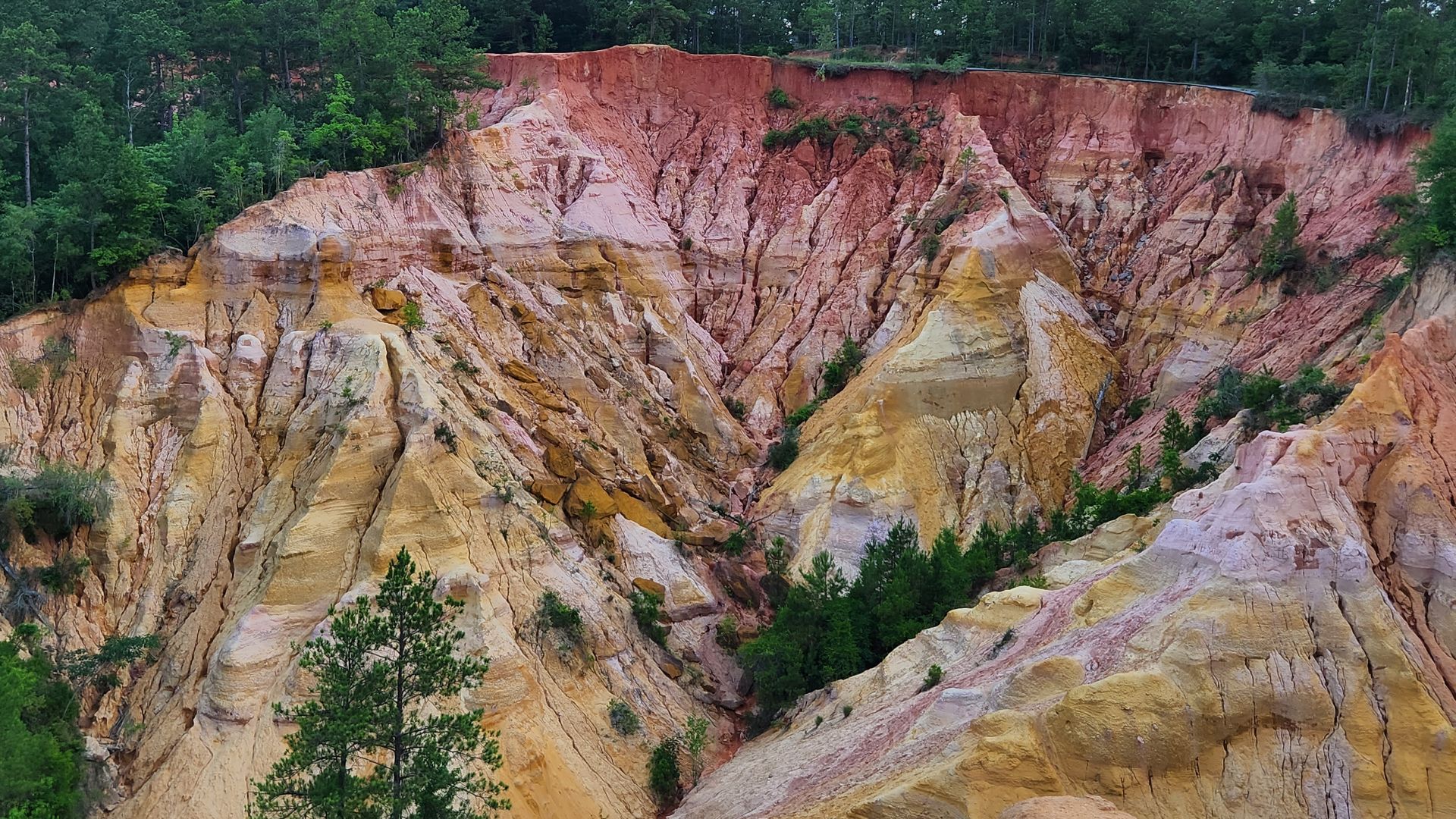
Georgia's Providence Canyon
Colorful gullies shaped by erosion and historic farming practices define Providence Canyon’s unusual terrain. Layers of red, orange, yellow, and brown clay form dramatic cliffs that earned it the nickname “Georgia’s Little Grand Canyon”. This place offers geological insight and striking scenery throughout this uniquely sculpted landscape.
 Thomsonmg2000, Wikimedia Commons
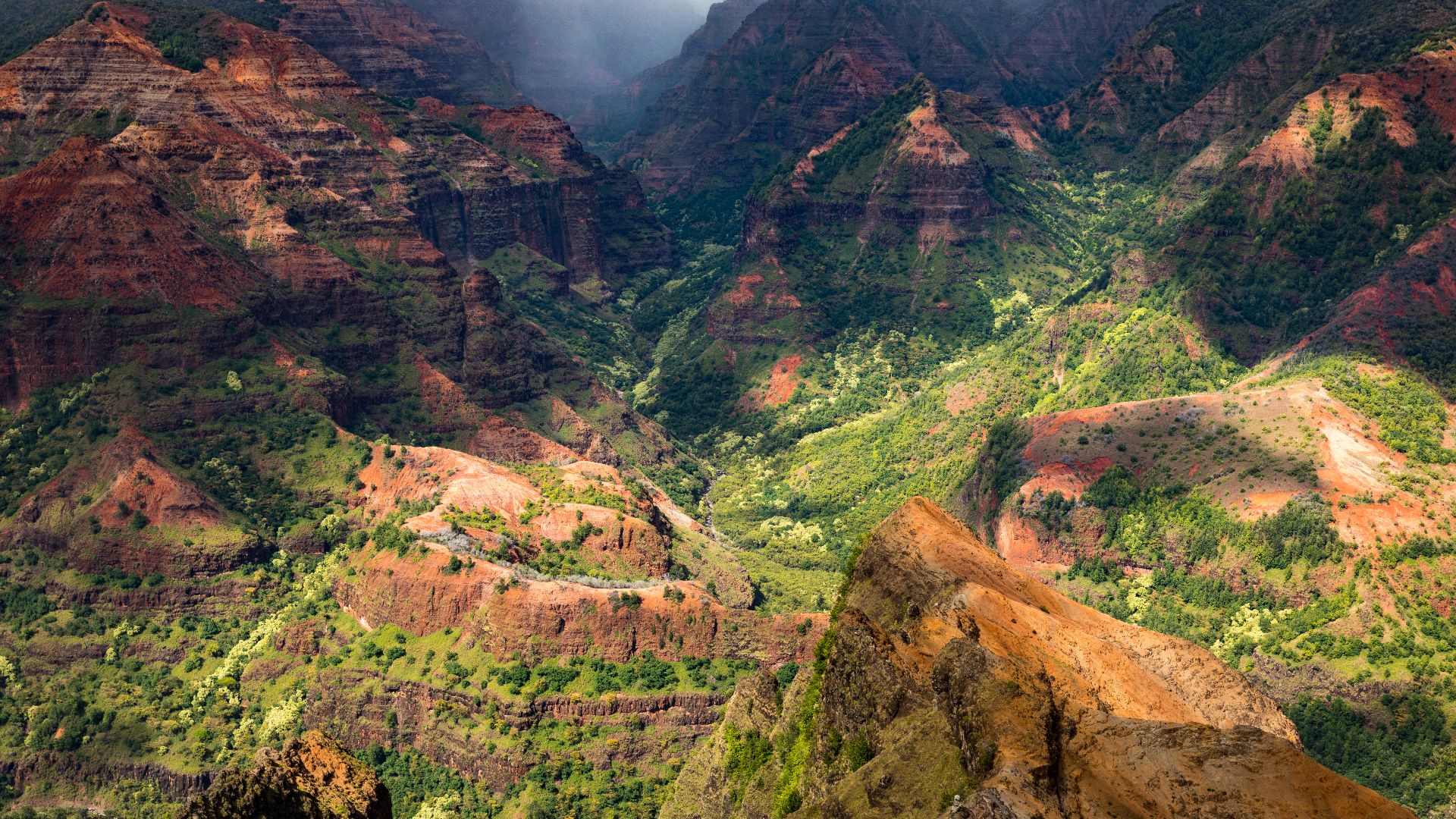
Hawaii's Waimea Canyon
On Kauai, Waimea Canyon opens into sweeping valleys and steep walls carved deeply over time. Iron-rich volcanic rock creates vivid red and green hues, while rainfall sustains lush vegetation along its 3,600-foot depths. These elements contribute to its reputation as the “Grand Canyon of the Pacific”.
 Frank Schulenburg, Wikimedia Commons
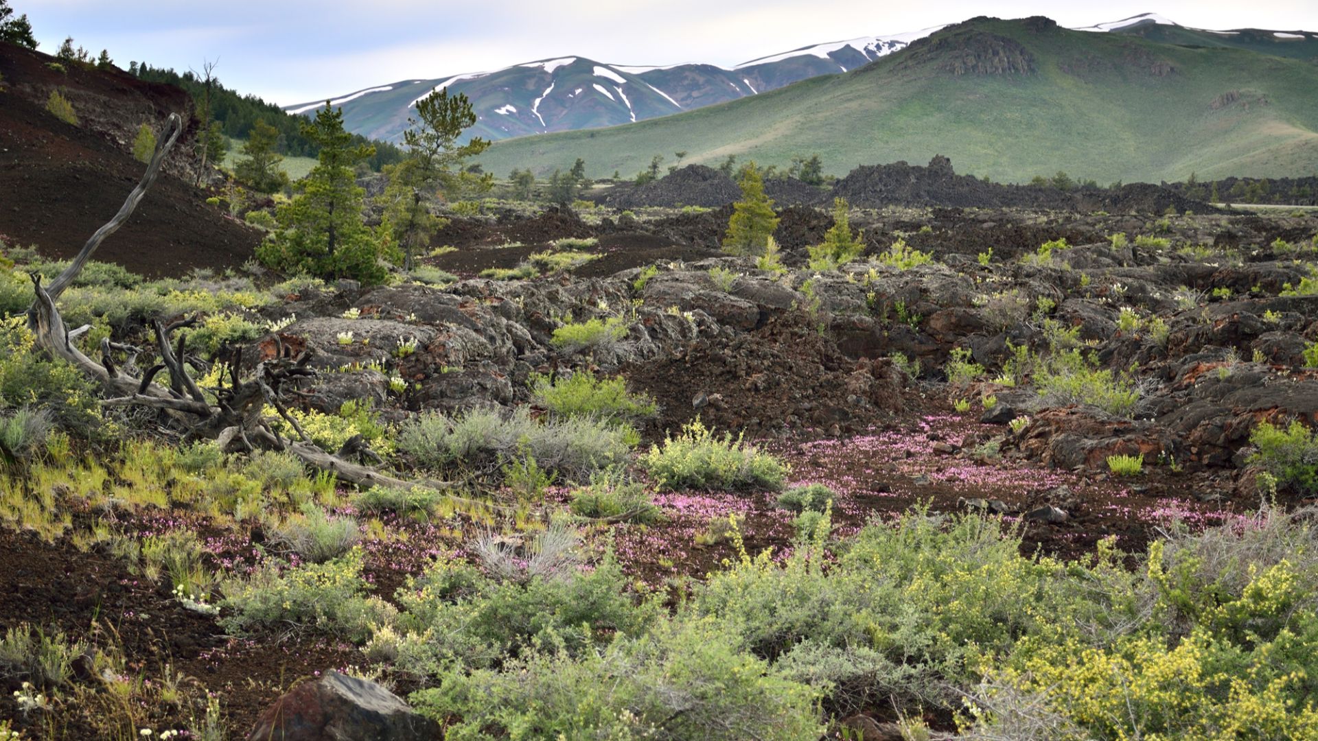
Idaho's Craters Of The Moon
Lava tubes and wide basalt flows shape the unusual terrain at Craters of the Moon. The volcanic formations stretch across a rugged landscape that resembles an otherworldly setting, a distinction that supported its designation as a National Monument and secured its evocative name.
 Bureau of Land Management, Wikimedia Commons
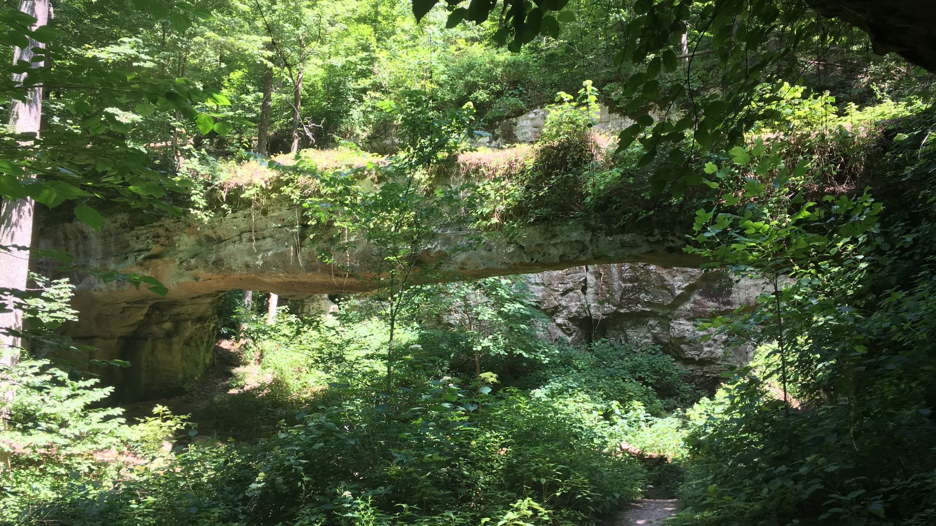
Illinois's Pomona Natural Bridge
In southern Illinois, Pomona Natural Bridge spans a sandstone ravine formed through long-term erosion. Its simple arch contrasts with the state’s other notable geological features, including the canyons of Starved Rock and dramatic rock formations found elsewhere. It remains a distinctive landmark for its quiet, sculpted beauty.
 Mrostrichman, Wikimedia Commons
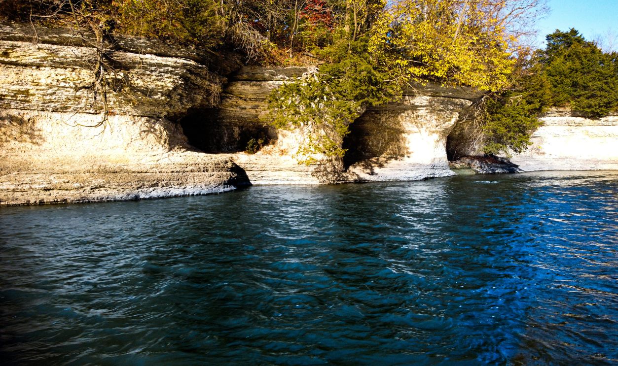
Indiana's Seven Pillars Of Peru
Rising above the Mississinewa River, the Seven Pillars of Peru form a row of sandstone columns shaped by natural erosion. While Indiana also holds notable sites such as Marengo Cave and the Indiana Dunes, these pillars stand out as the state’s most striking rock formation.
 JacobEckDronePhotography, Shutterstock
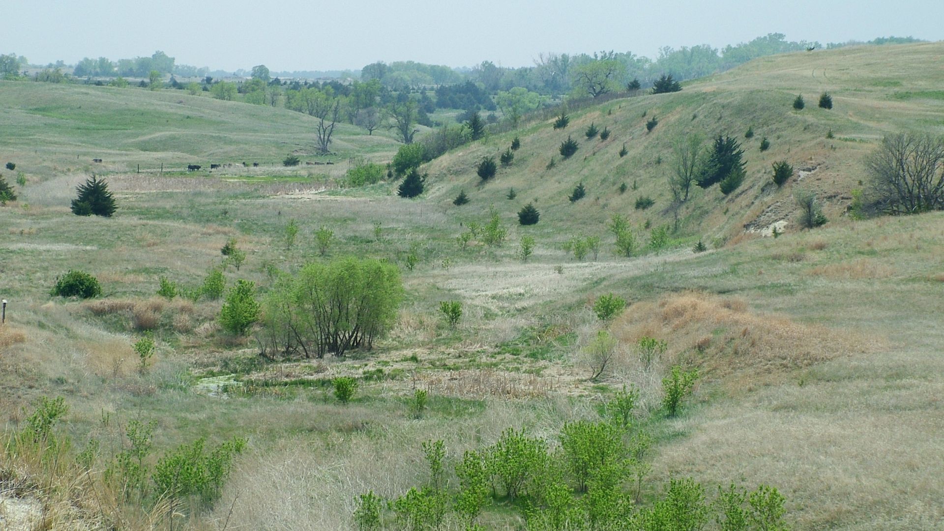
Iowa's Loess Hills
Stretching roughly 200 miles along Iowa’s western border, the Loess Hills form the world’s largest continuous loess deposit. Wind-blown glacial silt created steep ridges and some of the planet’s thickest loess layers. They spread across about 640 square miles and support rare prairie ecosystems shaped during the Ice Age.
 Bill Whittaker, Wikimedia Commons
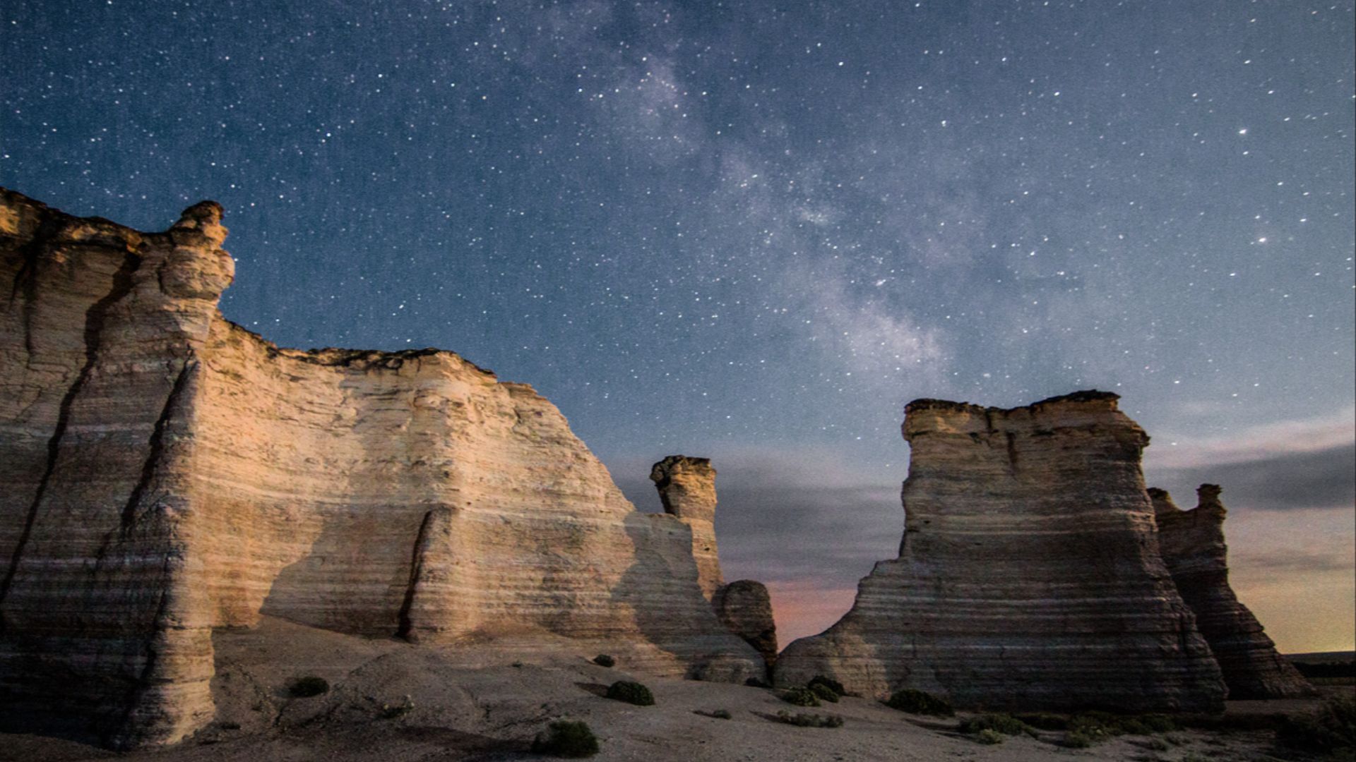
Kansas's Monument Rocks
In western Kansas, Monument Rocks rise from the former seafloor, with 70-foot chalk and limestone formations packed with fossils. Created by the Western Interior Seaway more than 80 million years ago, these towering outcrops display ammonites, fish, and marine reptiles.
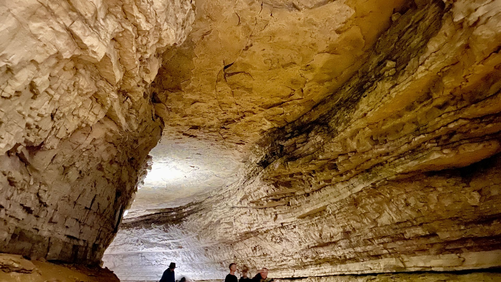
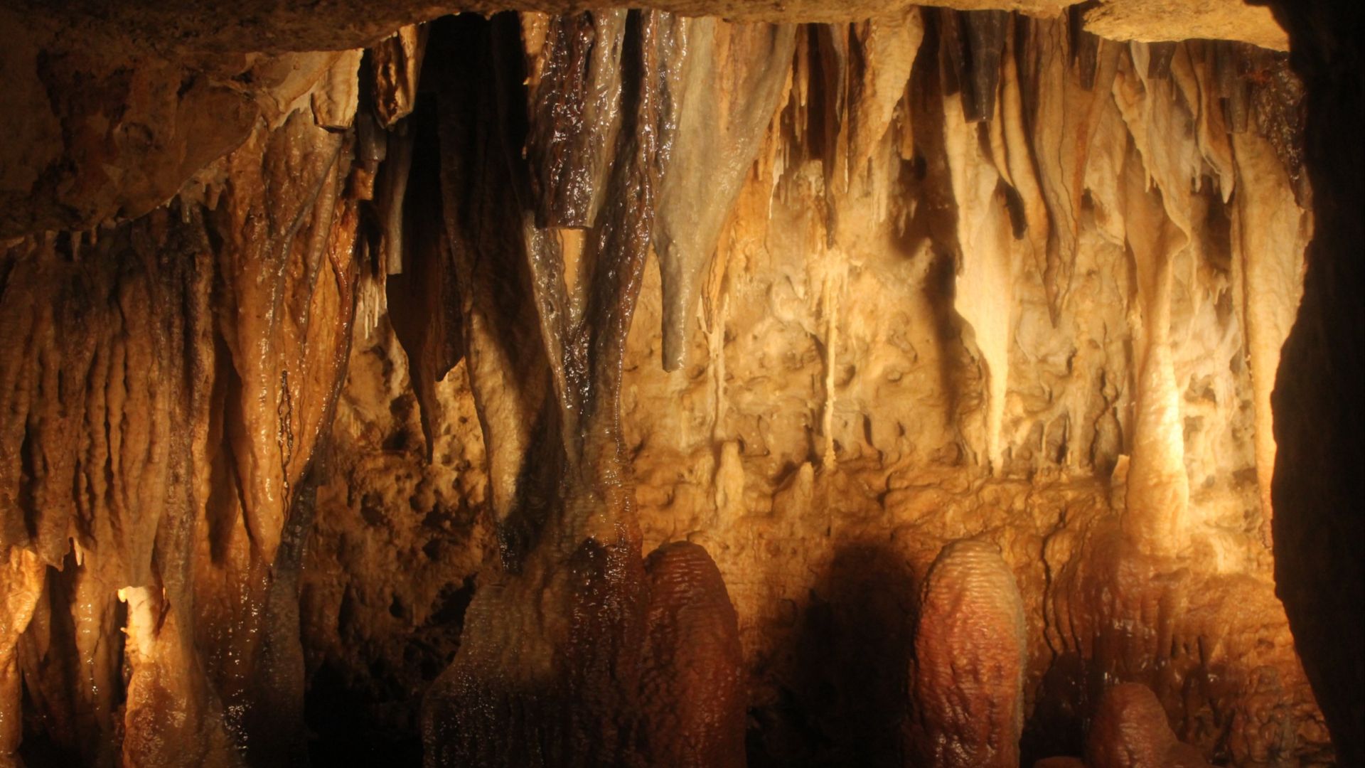
Kentucky's Mammoth Cave
Mammoth Cave extends for more than 400 miles to form the longest known cave system on Earth. Its explored passages and cave-adapted wildlife lie within Mammoth Cave National Park, a UNESCO World Heritage Site that represents Kentucky’s most iconic natural wonder with more than 420 miles of mapped caverns.
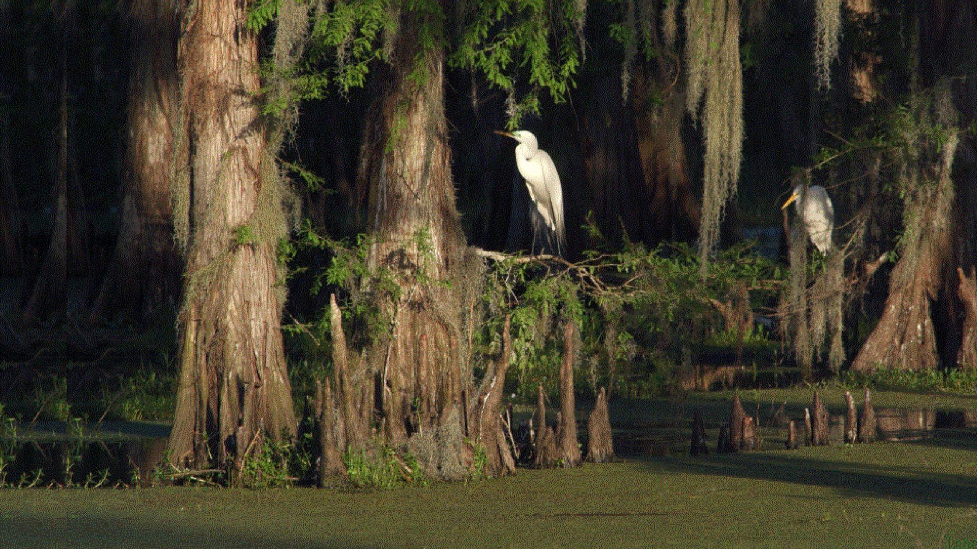
Louisiana's Atchafalaya Basin
Spanning roughly 1.4 million acres, the Atchafalaya Basin forms North America’s largest river swamp. Cypress forests and winding wetlands provide habitat for alligators and migratory birds. As the nation’s biggest river swamp and delta system, it anchors Louisiana’s most expansive wildlife refuge.
 Team New Orleans, US Army Corps of Engineers, Wikimedia Commons
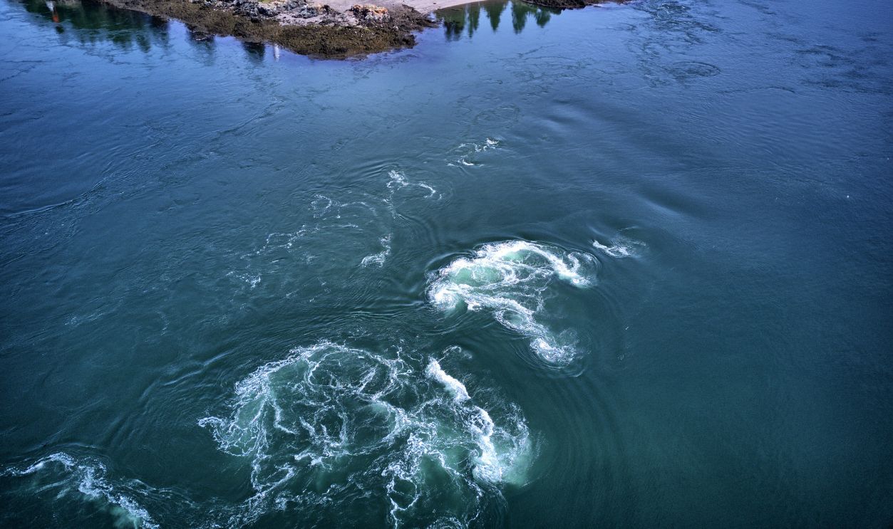
Maine's Old Sow Whirlpool
Between Moose Island in Maine and Deer Island in New Brunswick, Old Sow Whirlpool creates the Western Hemisphere’s largest tidal whirlpool. Strong Bay of Fundy currents funnel through a narrow passage to generate this dramatic rotating feature, which sits directly along the US–Canada boundary near Eastport.
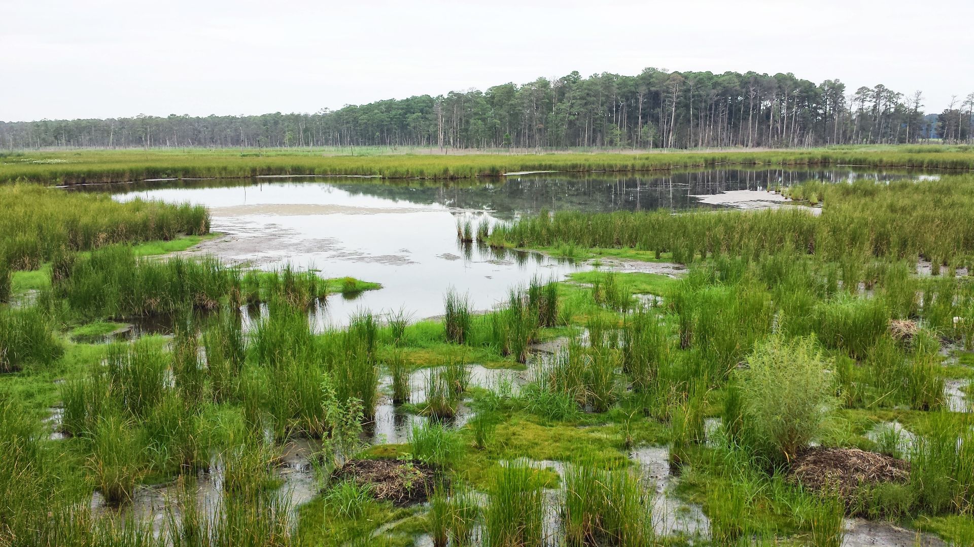
Maryland's Blackwater National Wildlife Refuge
Blackwater National Wildlife Refuge protects 28,000 acres of tidal marsh on Maryland’s Eastern Shore. Migratory waterfowl, bald eagles, and other rare species depend on these coastal wetlands. These locations form the state’s largest tidal marsh system and a critical habitat recognized for its ecological significance.
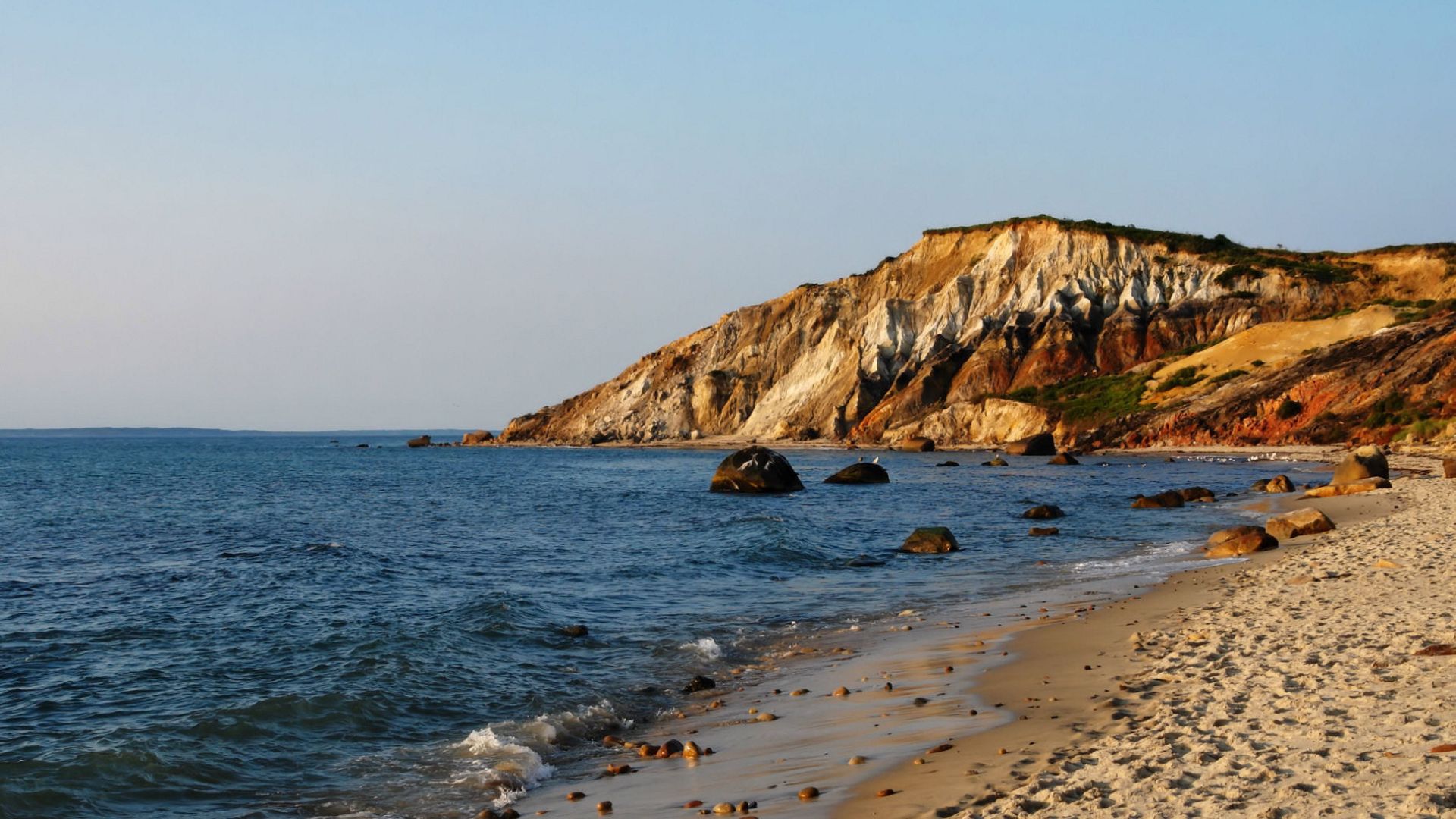
Massachusetts's Aquinnah Cliffs
On Martha’s Vineyard, Aquinnah Cliffs rise up to 150 feet above the Atlantic, displaying vivid red, orange, and white clay layers shaped over millennia. These multicolored formations hold cultural significance for the Wampanoag Tribe and remain one of Massachusetts’s most admired geological landmarks.
 Alberto Fernandez Fernandez, Wikimedia Commons
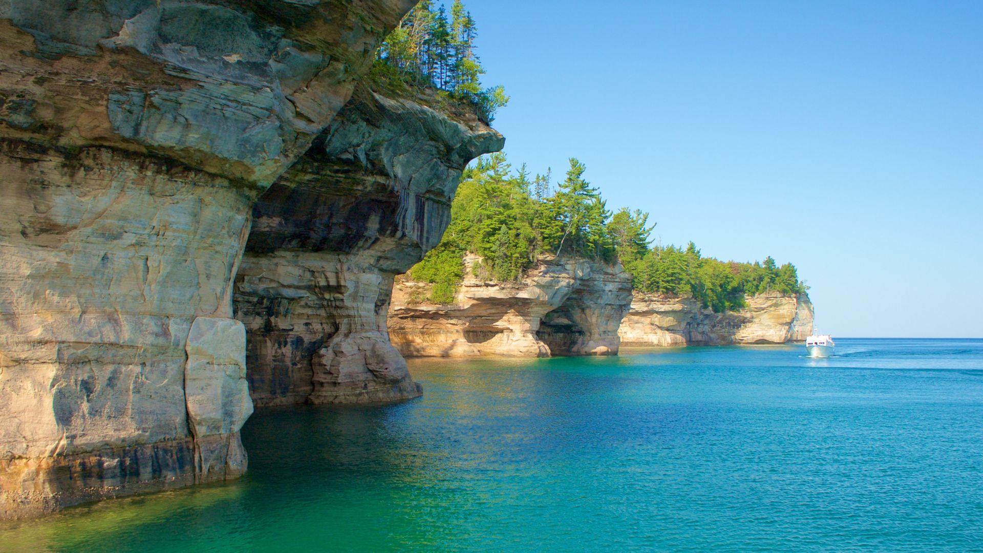
Michigan's Pictured Rocks National Lakeshore
Along Lake Superior, Pictured Rocks presents sandstone cliffs reaching nearly 200 feet high, streaked with red, orange, yellow, and brown from iron oxide and mineral deposits. Siltstone and shale add texture to the shoreline to create the colorful formations that define Michigan’s most celebrated natural wonder.
Minnesota's Niagara Cave
Revealing a 60-foot underground waterfall, the Niagara Cave houses stalactites, stalagmites, and mineral formations shaped over thousands of years. An active stream runs through the cave, reached only by guided tours. Seasonal winter closures limit access, yet it’s one of Minnesota’s most visually striking underground spots.
 Tisius Syracuse, Wikimedia Commons
Mississippi's Red Bluff
Near Foxworth, Red Bluff rises nearly 200 feet above the Pearl River valley, exposing red clay and layers carved by constant erosion. Known as the “Grand Canyon of the Mississippi,” its bright cliffs shift and expand over time, creating a dramatic landscape favored by hikers and geology enthusiasts.
 Destroyanad, Wikimedia Commons
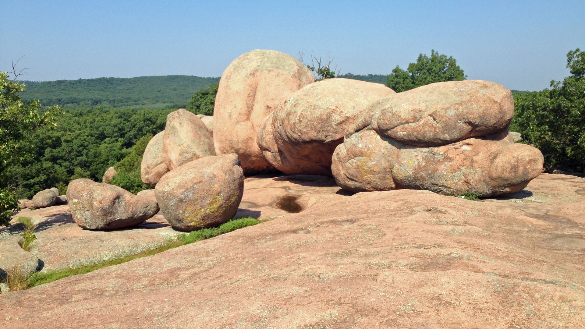
Missouri's Elephant Rocks
Showcasing massive Precambrian granite boulders, some of the formations found in Missouri’s Elephant Rocks State Park are roughly 1.5 billion years old. Some reach more than 27 feet across and naturally line up in formations resembling a herd of elephants. These ancient granite blocks highlight the distinctive geology of the St Francois Mountains.
 Fredlyfish4, Wikimedia Commons
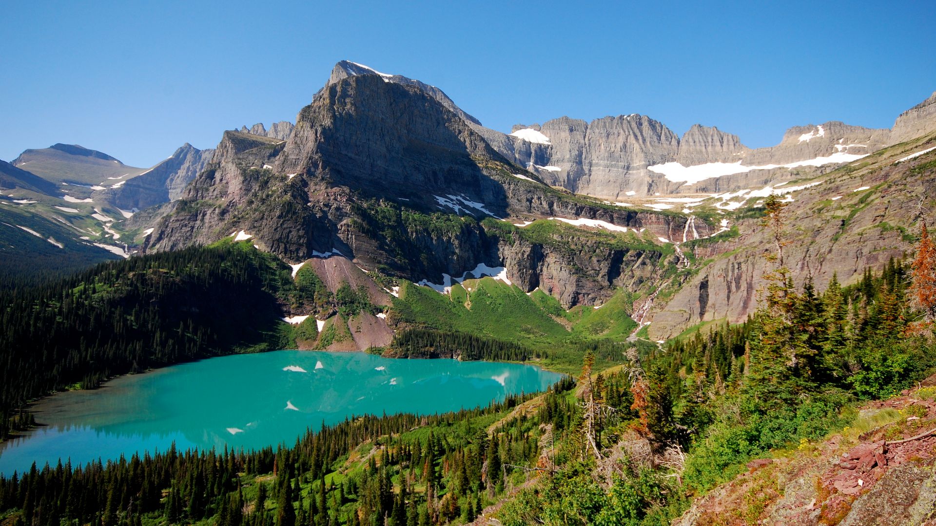
Montana's Grinnell Glacier
Within Glacier National Park, part of the UNESCO-recognized Waterton-Glacier International Peace Park, Grinnell Glacier sits among rugged peaks and vivid alpine lakes. Named for conservationist George Bird Grinnell, the glacier represents one of Montana’s most iconic high-country landscapes and reflects the dramatic mountain scenery that defines the region.
 Distress.bark, Wikimedia Commons
Nebraska's Ashfall Fossil Beds
Ashfall Fossil Beds preserve a volcanic ash layer dating roughly 10–12 million years and capture entire Miocene ecosystems in remarkable detail. Rhinoceroses, camels, and other mammals lie preserved as complete skeletons within the ash. This rare site provides a direct window into prehistoric Nebraska and its ancient wildlife communities.
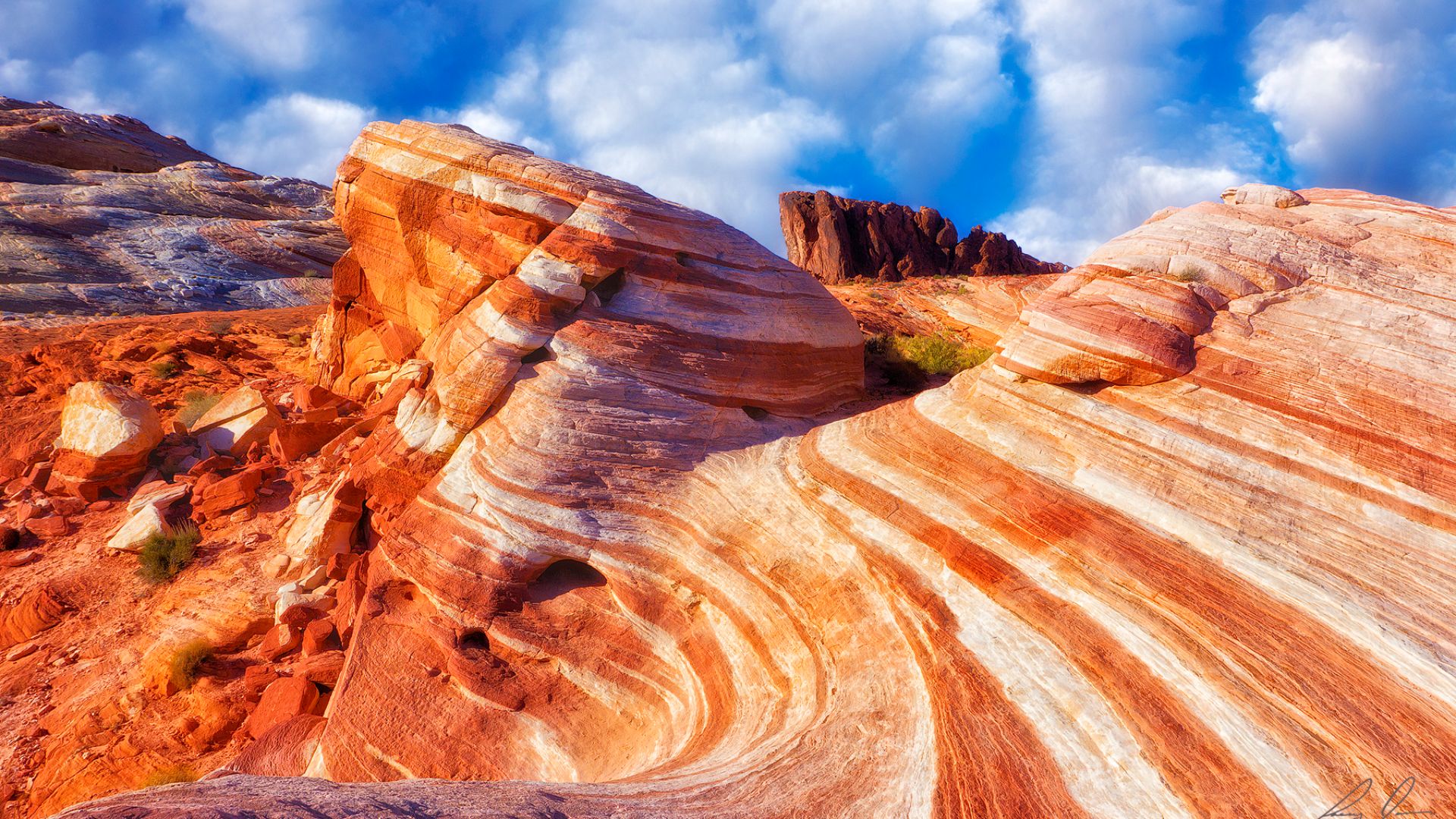
Nevada's Valley Of Fire
Across 42,000 acres, Valley of Fire State Park glows with red and multicolored Aztec sandstone shaped by long-term erosion. Sunlight intensifies the rock’s fiery appearance, while ancient petroglyphs add cultural depth. These vivid formations create a visually distinctive desert landscape and one of its signature geological wonders.
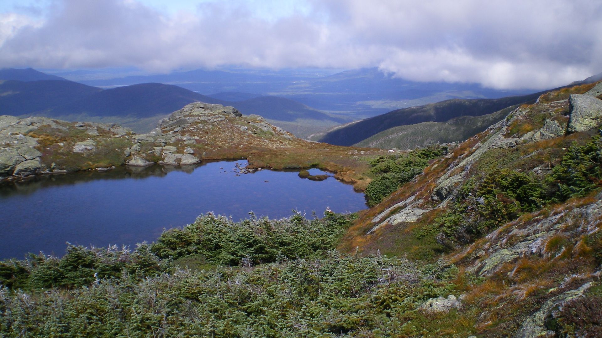
New Hampshire's Lakes Of The Clouds
Shaped by glacial activities, the Lakes of the Clouds occupy a high-elevation basin set at about 5,032 feet on Mount Washington’s southern slope. These alpine tarns lie near the historic hut and support fragile subalpine plants. Hikers on Crawford Path and Ammonoosuc Ravine reach sweeping views of the rugged terrain.
 Paulbalegend at English Wikipedia, Wikimedia Commons
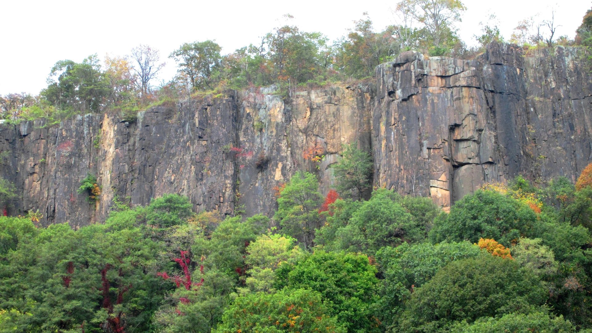
New Jersey's Palisades Cliffs
Located along the Hudson River, the Palisades rise 300–550 feet in towering columnar basalt. They were formed nearly 200 million years ago during Pangaea’s breakup, and the cliffs extend about 20 miles along the New Jersey–New York border. Their volcanic origins and dramatic escarpment earned recognition as a National Natural Landmark.
 Beyond My Ken, Wikimedia Commons
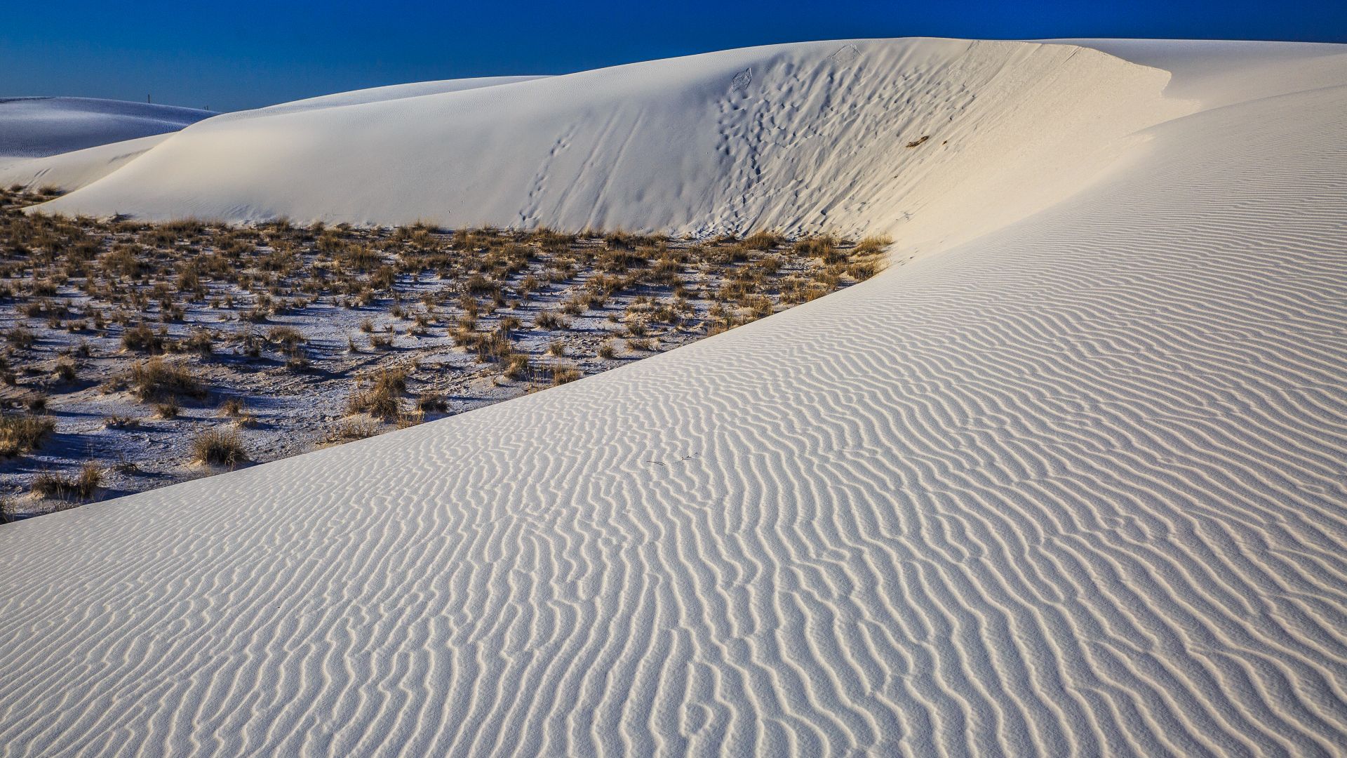
New Mexico's White Sands National Park
Spreading across roughly 146,000 acres, White Sands National Park holds the world’s largest gypsum dune field. The bright sand stays cool under intense heat because gypsum doesn’t retain warmth. Unique species such as the bleached earless lizard and Apache pocket mouse survive within this striking white-sand environment.
 Murray Foubister, Wikimedia Commons
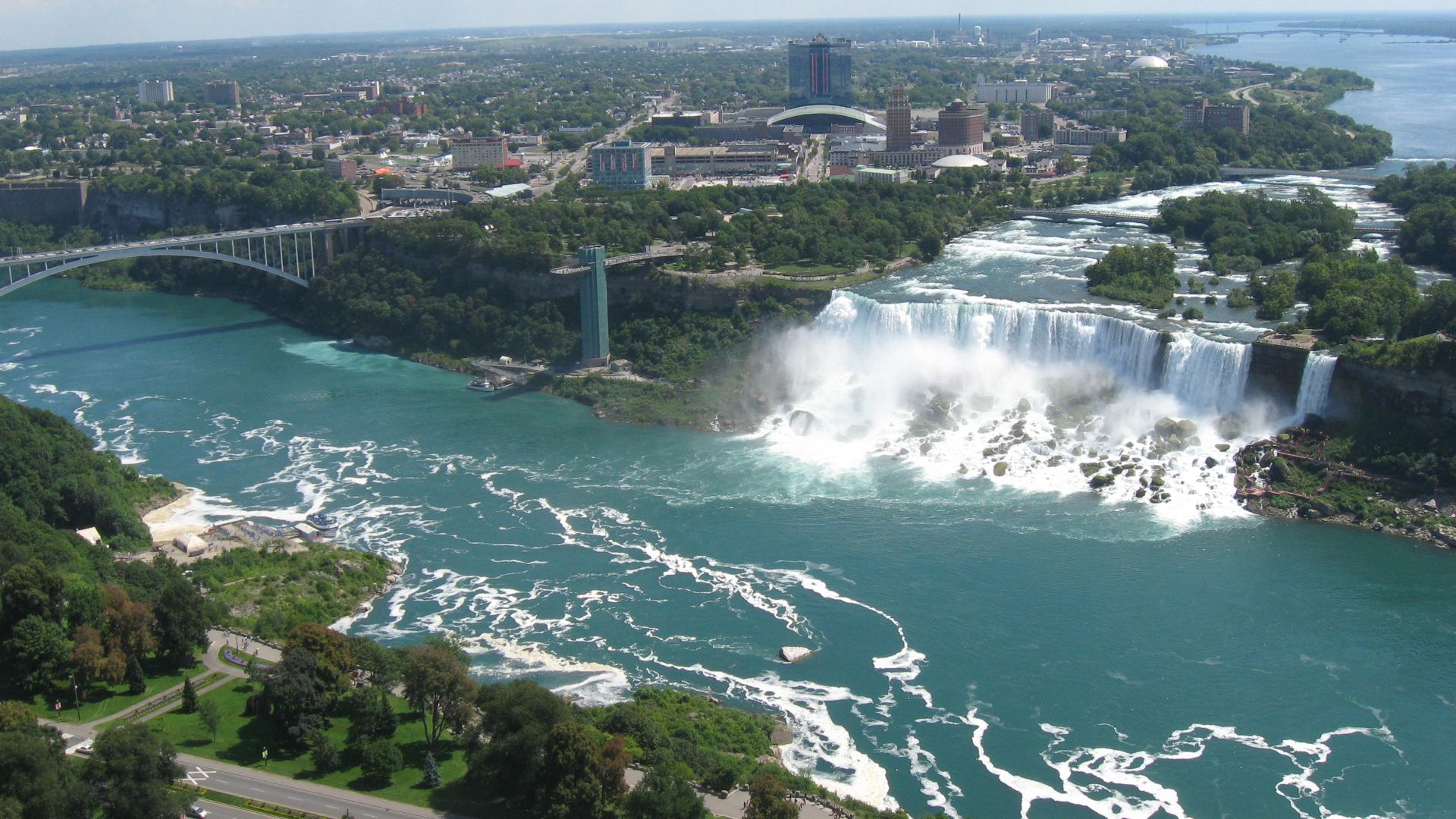
New York's Niagara Falls
Niagara Falls are located at the border between New York and Canada, where Horseshoe Falls, American Falls, and Bridal Veil Falls release between 500,000 and 700,000 gallons of water each second. Formed during the last Ice Age, this powerful waterfall system remains one of North America’s most iconic natural landmarks.
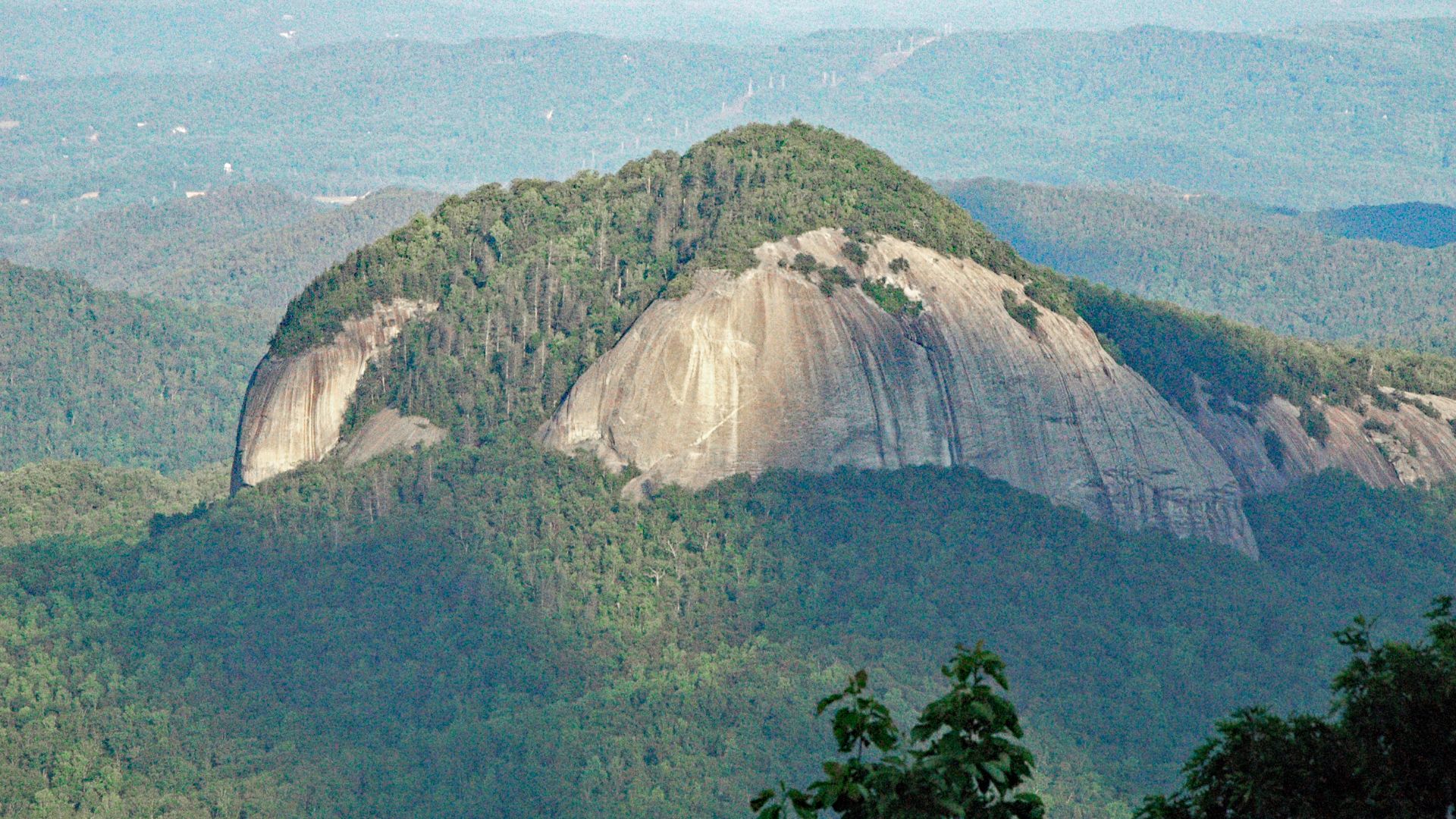
North Carolina's Looking Glass Rock
As a prominent quartzite dome, the Looking Glass Rock rises from the Blue Ridge Mountains with a reflective cliff face that glows after rainfall. While Linville Gorge holds statewide renown for its 2,000-foot-deep river canyon, this peak stands out for panoramic trails and broad mountain views.
 James St. John, Wikimedia Commons
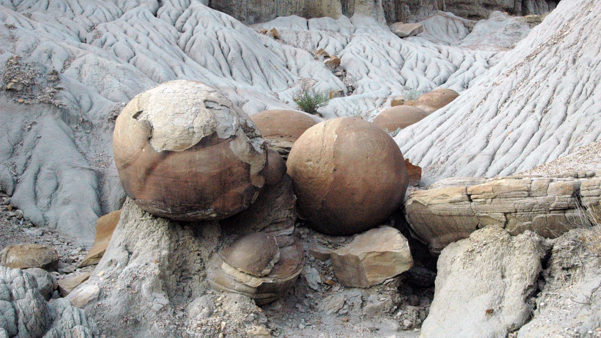
North Dakota's Cannonball Concretions
Along the Missouri River, Cannonball Concretions appear as naturally rounded ironstone spheres created by mineral precipitation around organic centers roughly 60 million years ago. These formations vary from small stones to multi-foot boulders. Although modest beside larger state landmarks, they remain distinctive examples of Paleocene sediment processes.
 James St. John, Wikimedia Commons
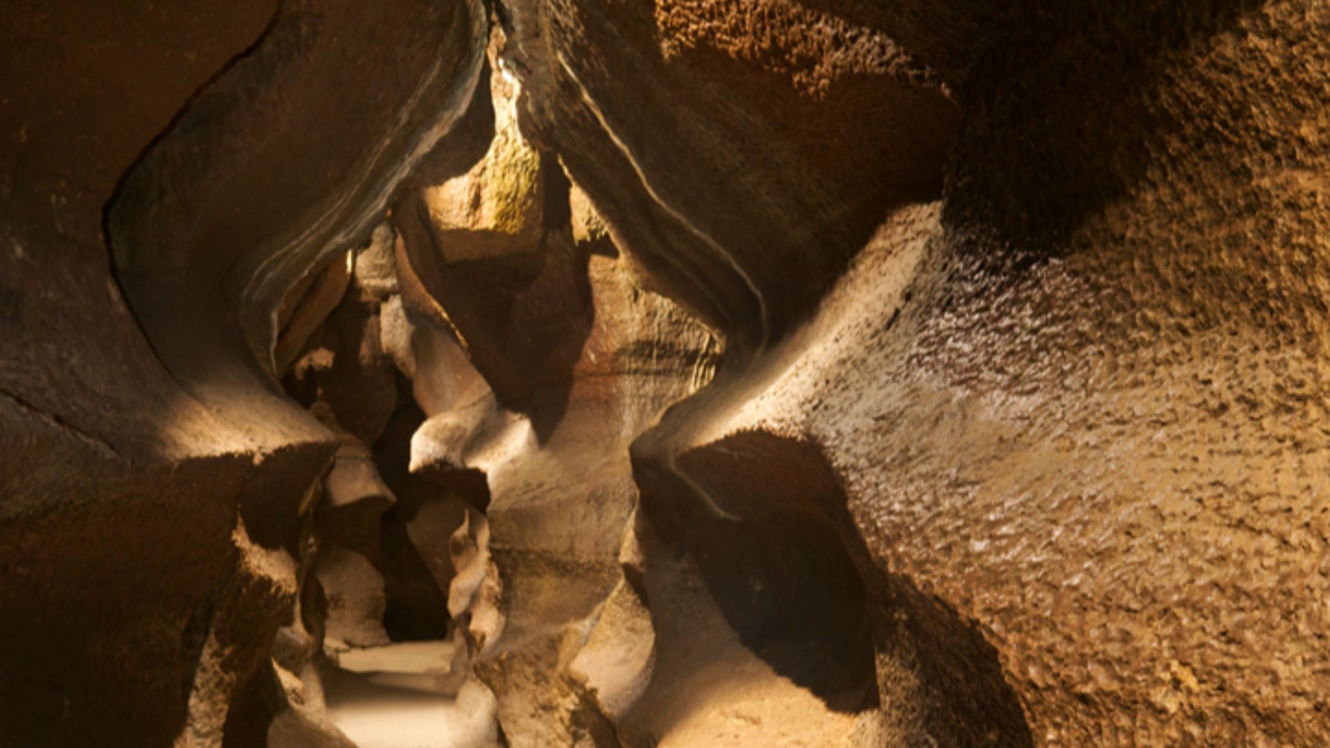
Ohio's Crystal King And The Ohio Caverns
Ohio Caverns contains the state’s most extensive show-cave system, filled with stalactites and striking crystal formations, including the Crystal King, an immense stalactite regarded as one of the nation’s largest. Guided tours reveal active mineral growth and chambers shaped by groundwater carving through ancient limestone.

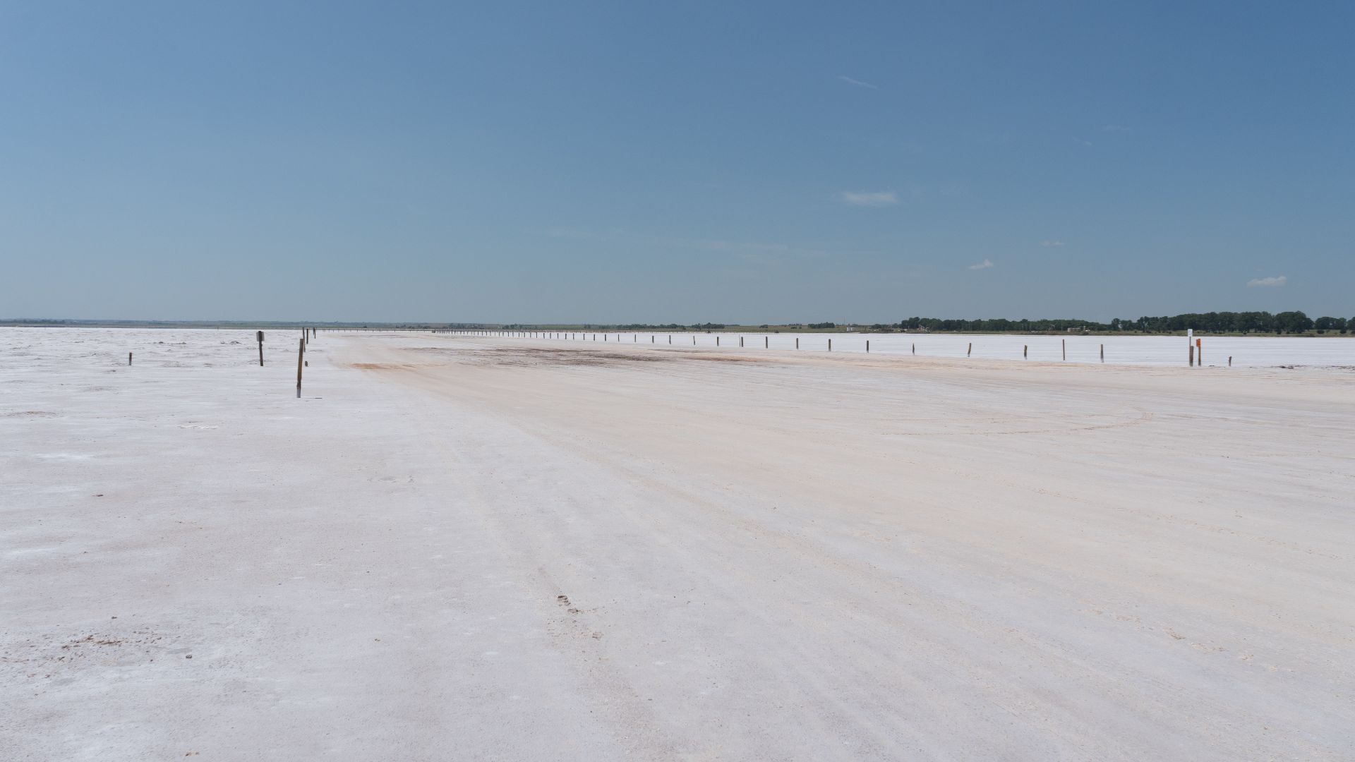
Oklahoma's Great Salt Plains
Across 11,000 acres, the Great Salt Plains form a broad salt flat shaped by evaporated ancient seawater. This National Wildlife Refuge protects migratory birds and allows visitors to dig for rare hourglass-shaped selenite crystals, one of the only places on Earth where these unique formations occur.
 Shujianyang, Wikimedia Commons
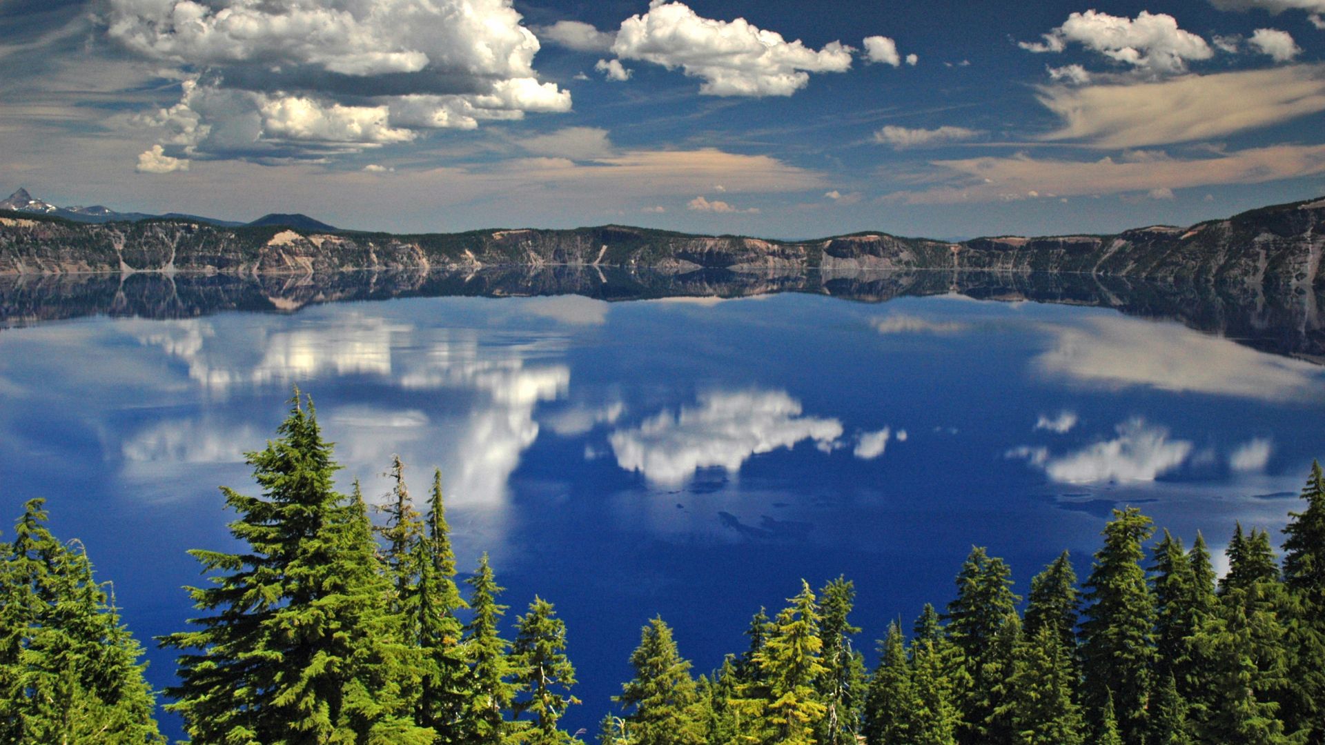
Oregon's Crater Lake
Crater Lake fills a volcanic caldera formed about 7,700 years ago after Mount Mazama collapsed. At 1,949 feet, it is the deepest lake in the United States. Rain and snow alone replenish its intensely blue water, as no rivers flow into or out of the basin.
 Jeffrey Johnson from Bergen County, New Jersey, USA, Wikimedia Commons
Pennsylvania's Ringing Rocks
Representing a natural boulder field, Ringing Rocks are located in Upper Black Eddy, where striking certain stones produces metallic tones. Their unusual resonance stems from internal stress and mineral makeup. Visitors often tap the “musical” rock pile, creating a rare acoustic effect found only in select geological formations.
 christianthiel.net, Shutterstock
Rhode Island's Block Island
Block Island presents steep sea cliffs and rare maritime habitats shaped by glacial activity. Mohegan Bluffs rise 200 feet above the Atlantic, sheltering delicate plant communities and migratory birds. Although other coastal features define Rhode Island, this is one of its most dramatic natural settings.
 Timothy J. Quill, Wikimedia Commons
South Carolina's 40 Acre Rock
Within the 40 Acre Rock Heritage Preserve, a broad granite outcrop rises about 200 feet above the surrounding terrain, supporting vernal pools, lichens, and endangered plants across fragile Piedmont habitats. Nearby forests and wetlands broaden the preserve’s biodiversity, even as Congaree National Park holds wider statewide recognition.
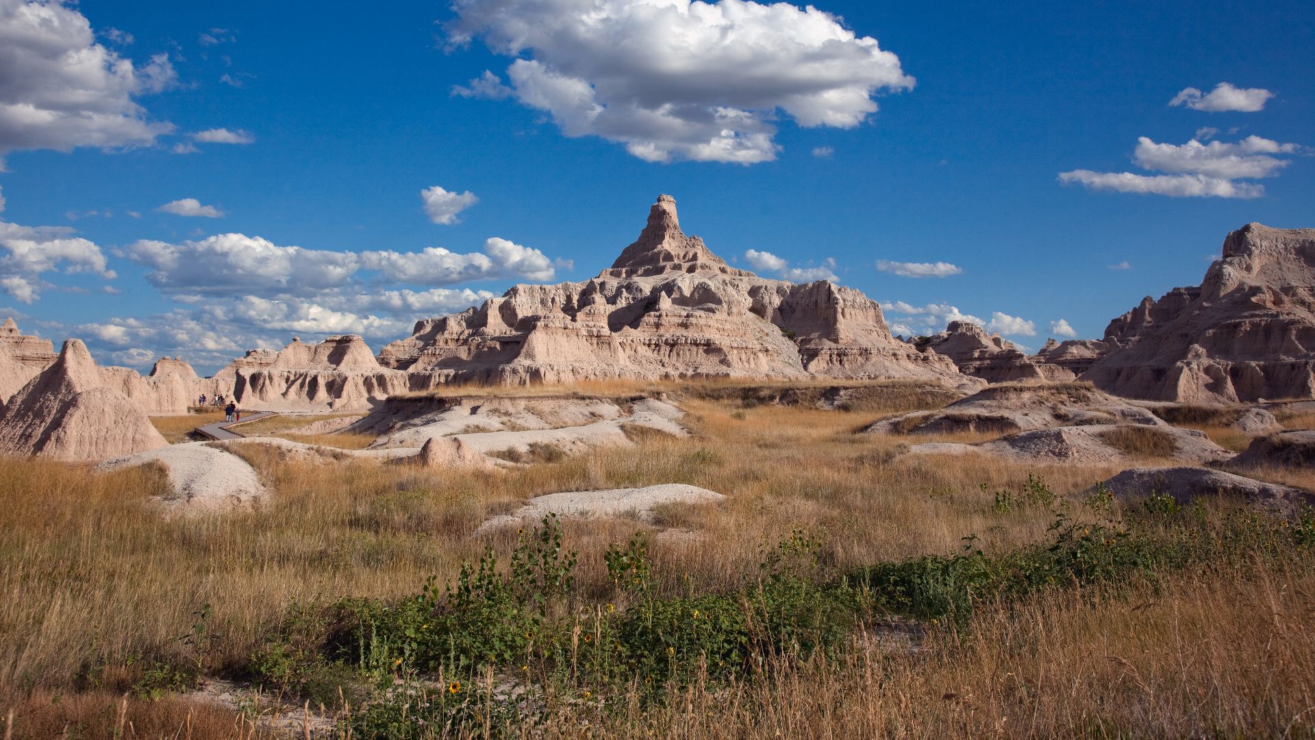
South Dakota's Badlands National Park
Badlands National Park reveals sharply eroded buttes and spires shaped over millions of years. Fossil beds dating back 37 million years preserve ancient mammals, while bison, prairie dogs, and bighorn sheep inhabit the present-day terrain. At sunrise and sunset, the layered formations shift dramatically in color.
 Carol M. Highsmith, Wikimedia Commons
Tennessee's Craighead Caverns
Craighead Caverns houses the Lost Sea, a 4.5-acre underground lake recognized as the largest in the United States. Guided boat tours glide across its cool, still water to reveal mineral formations. The broad cavern chambers make this subterranean landscape Tennessee’s most distinctive natural wonder beneath the surface.
 Oydman (talk), Wikimedia Commons
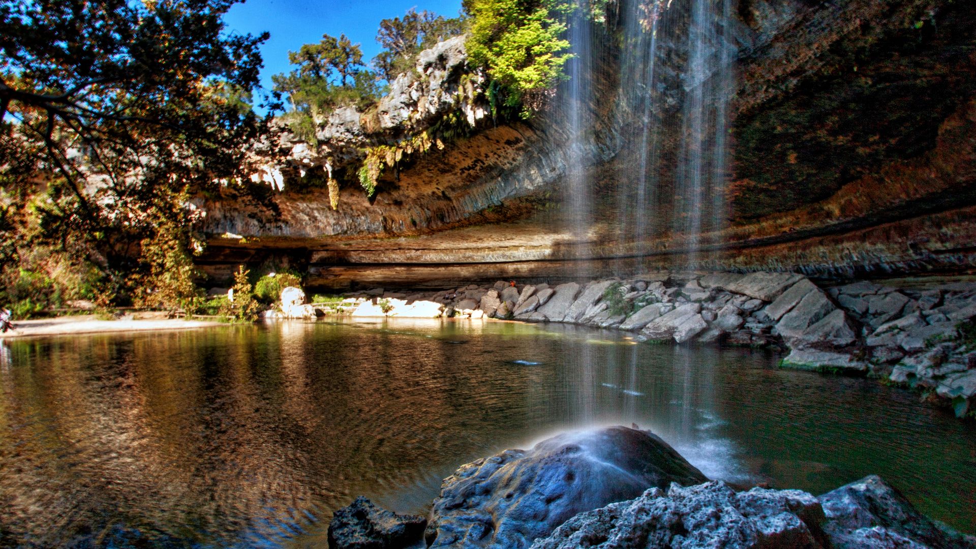
Texas's Hamilton Pool Preserve
When an underground river’s limestone ceiling collapsed in Texas, the Hamilton Pool Preserve was formed thousands of years ago with a turquoise pool beneath a wide grotto. A seasonal waterfall drops fifty feet into the basin, though flow diminishes during dry periods.
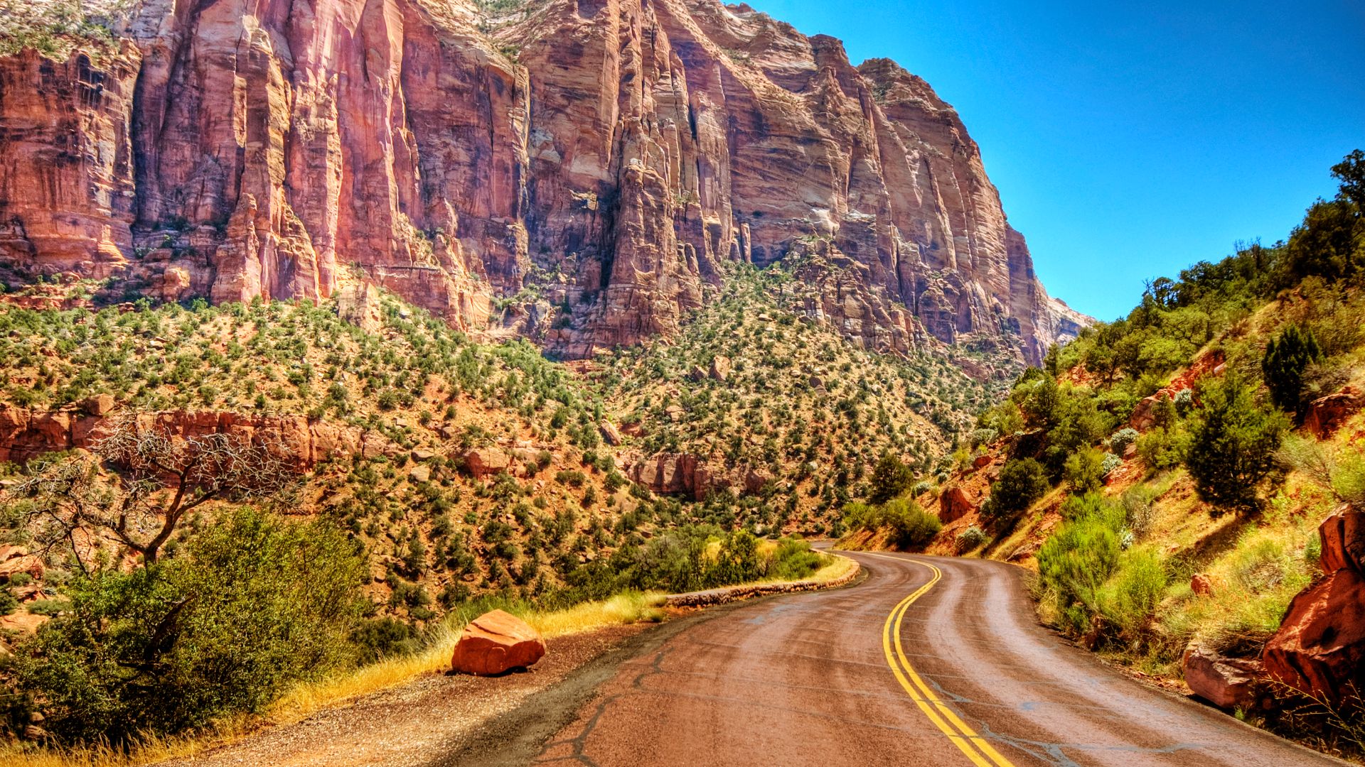
Utah's Zion Canyon
Zion Canyon narrows between towering sandstone walls carved by the Virgin River. Light shifts across the cliffs throughout the day, deepening reds and softening golds, while the Angels Landing trail climbs along dramatic drop-offs above the gorge. These elements combine to define Utah’s most iconic canyon landscape.
 Wolfgang Staudt from Saarbruecken, Germany, Wikimedia Commons
Vermont's The Green Mountains
Extending the length of Vermont, the Green Mountains rise toward Mount Mansfield at 4,393 feet, where rare alpine tundra survives along rugged cliffs. The Long Trail, established in 1910, follows this range’s ridgeline. It highlights its role as Vermont’s defining natural corridor and most recognizable mountain environment.
Virginia's The Great Channels
Although Shenandoah National Park anchors Virginia’s mountain scenery with its Blue Ridge vistas and a 105-mile stretch of protected wilderness, the Great Channels highlight an even more unusual geologic setting: narrow sandstone passageways carved by ancient forces atop Clinch Mountain. Their maze-like corridors create one of Virginia’s rarest natural features.
Washington's The Enchantments
High in the Alpine Lakes Wilderness, the Enchantments basin holds dozens of glacial lakes surrounded by sharp granite peaks and bright alpine meadows. Its turquoise water and fragile high-country terrain make this the premier wilderness destination in Washington, accessible only through a demanding permit-controlled trail system.
West Virginia's Dolly Sods Wilderness Area
Dolly Sods rises above 3,000 feet as a high-elevation plateau marked by heath barrens and boggy mountain meadows. Its alpine-like terrain contrasts sharply with the state’s river gorges for panoramic views and rare plant communities.
Wisconsin's Cave Of The Mounds
Cave of the Mounds reveals stalactites, stalagmites, flowstone, and clear underground pools shaped within Wisconsin’s karst limestone. Year-round guided tours explore chambers filled with colorful mineral formations, highlighting the slow geological processes that created the state’s most celebrated show cave.
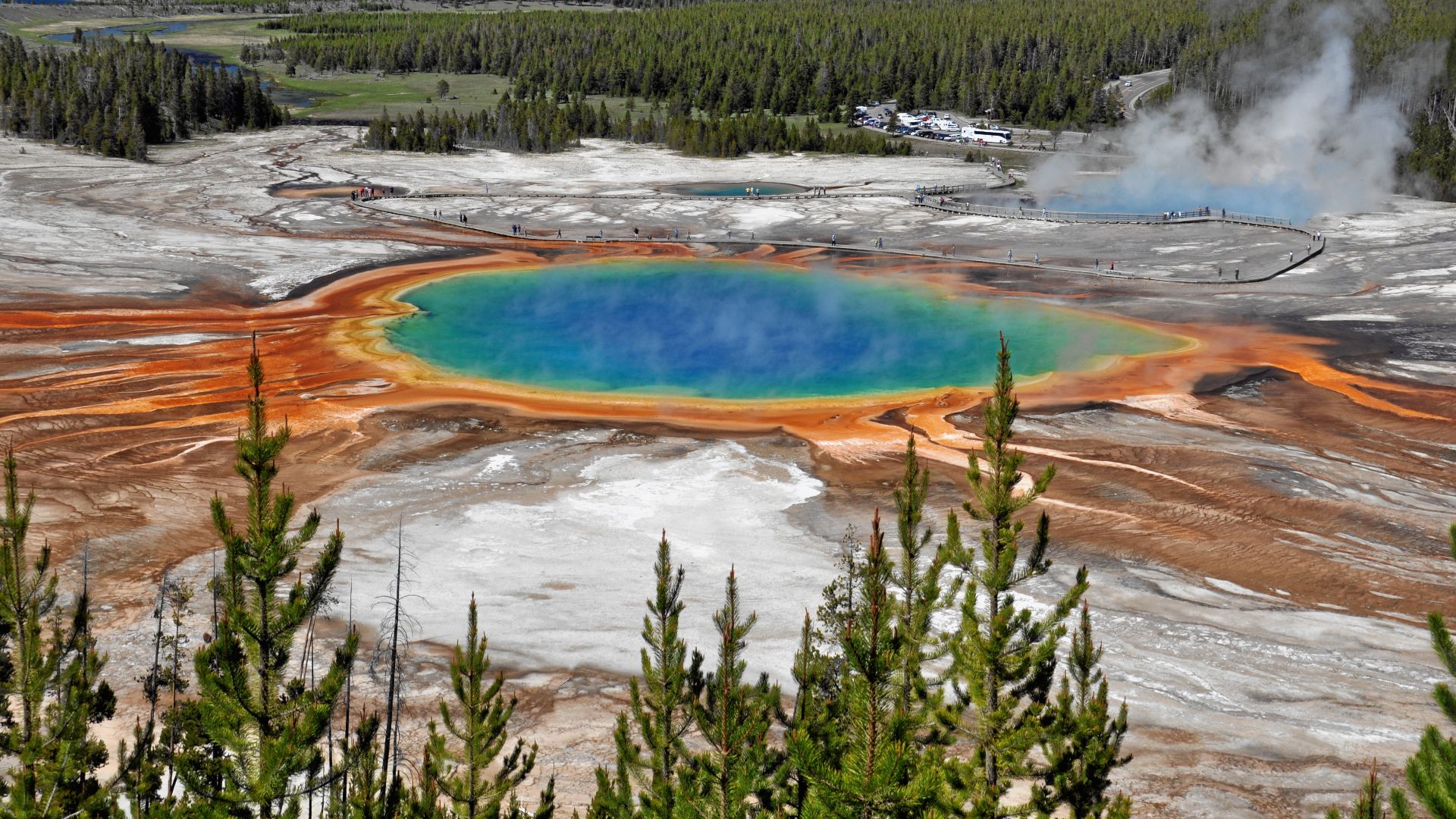
Wyoming's Yellowstone National Park
Designated in 1872 as the world’s first national park, Yellowstone National Park spans more than 3,468 square miles. Old Faithful, Grand Prismatic Spring, and other geothermal features define its volcanic landscape, while grizzly bears and roaming bison herds add magic to Wyoming’s most iconic natural wonder.
 James St. John from Newark, Ohio, Wikimedia Commons