Ancient Metropolis Rediscovered
For centuries, Alexandria on the Tigris was just a blank space in the map of history, a once-thriving ancient trading port that eventually vanished under shifting riverbeds, sand, and human conflict. Now archaeologists have rediscovered this long-forgotten metropolis near the Tigris in southern Iraq. It is reshaping our knowledge of Alexander the Great’s vision and ancient commerce.

Alexander The Great’s Strategic Foundation
In the late fourth century BC, Alexander the Great planned a network of cities carrying his name across the Near East. Alexandria on the Tigris was only one of the last of these major urban foundations, situated at the junction of the Tigris and Karun rivers in Mesopotamia to lay out a new port linking inland empires and peoples with the Persian Gulf’s maritime routes.
 Unknown creatorUnknown creator, Wikimedia Commons
A New Port Was Needed
Alexander’s relentless campaign of conquest across the Persian Empire revealed a problem: sediment accumulating in southern waterways was pushing the Persian Gulf shoreline southward, and making the older harbors useless. To bypass this difficulty, he planned a new city near the river’s confluence that could act as a reliable gateway between inland trade and the open sea.
 Ali Rostami , Wikimedia Commons
Alexandria Becomes Charax Spasinou
Over time, this strategic port city came to be called Charax Spasinou or Charax Maishan under local rulers and later texts. But even with all the mentions in ancient sources like Pliny and Roman writings, its exact location was still maddeningly elusive to historians and archaeologists for centuries.

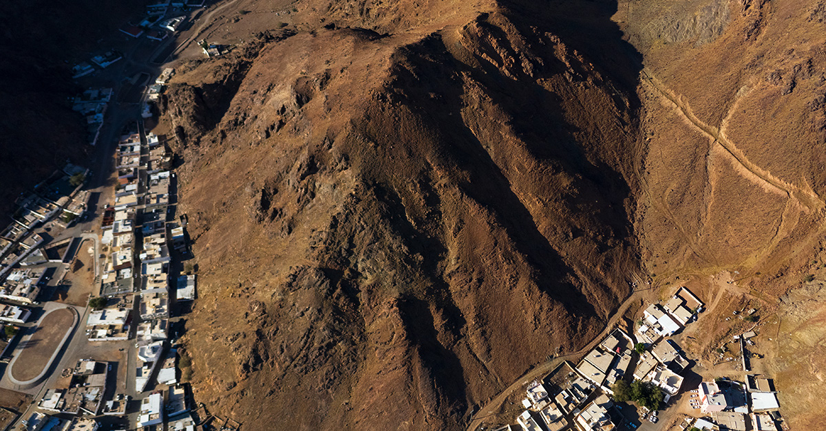
Early Clues From Air Photos
The first modern hints of the city’s location emerged in the 1960s, when British researcher John Hansman pinpointed enormous walls on RAF aerial photos. These fortifications stretched for kilometers, which suggested something along the lines of a major urban settlement. Unfortunately, the political instability of the time complicated attempts to carry out any immediate follow-up research.
 Royal Air Force official photographer, Wikimedia Commons
A Site Hard To Reach
Located near Jebel Khayyaber close to today’s Iran-Iraq border, the site was difficult and dangerous to access. Armed conflict, particularly the Iran–Iraq War of the 1980s, left the area heavily militarized, which put a damper on any archaeological investigation and left the city’s secrets encased beneath layers of more recent history.
 Mohammad Hassanzadeh, Wikimedia Commons
Teams Return In The 2010s
In 2014, international archaeologists, guided by local authorities, cautiously went back into the region. British researchers at first surveyed the area near the ancient city of Ur, but they were quickly directed to poke around the enigmatic walls at Jebel Khayyaber.
 M.Lubinski from Iraq,USA., Wikimedia Commons
Survey Techniques Without Digging
Due to the ongoing security situation, the team was dependent on noninvasive methods. They walked hundreds of kilometers across the dusty landscape, recorded surface finds, photographed the landscape with drones, and put together detailed digital terrain models that seemed to hint at buried structures and city layouts.

Mapping Streets And Structures
By now the project had added Stefan Hauser, one of the top experts in Hellenistic (Greek) Near Eastern archaeology. With geophysical tools like cesium magnetometers, the research team detected patterns below the surface: grid-like street networks, canals, residential blocks, large housing complexes, and even temple or palace areas. These results all strongly indicated the remains of a sprawling planned city.

Urban Plan On A Grand Scale
Analyses indicate that Alexandria on the Tigris may have been one of the largest cities of its era in Mesopotamia and the Near East. Its organized grid layout, wide streets, and public structures all show the signs of deliberate long-term planning far beyond the temprorary nature of a simple river outpost.
 Karl Spruner von Mertz / Heinrich Theodor Menke, Wikimedia Commons
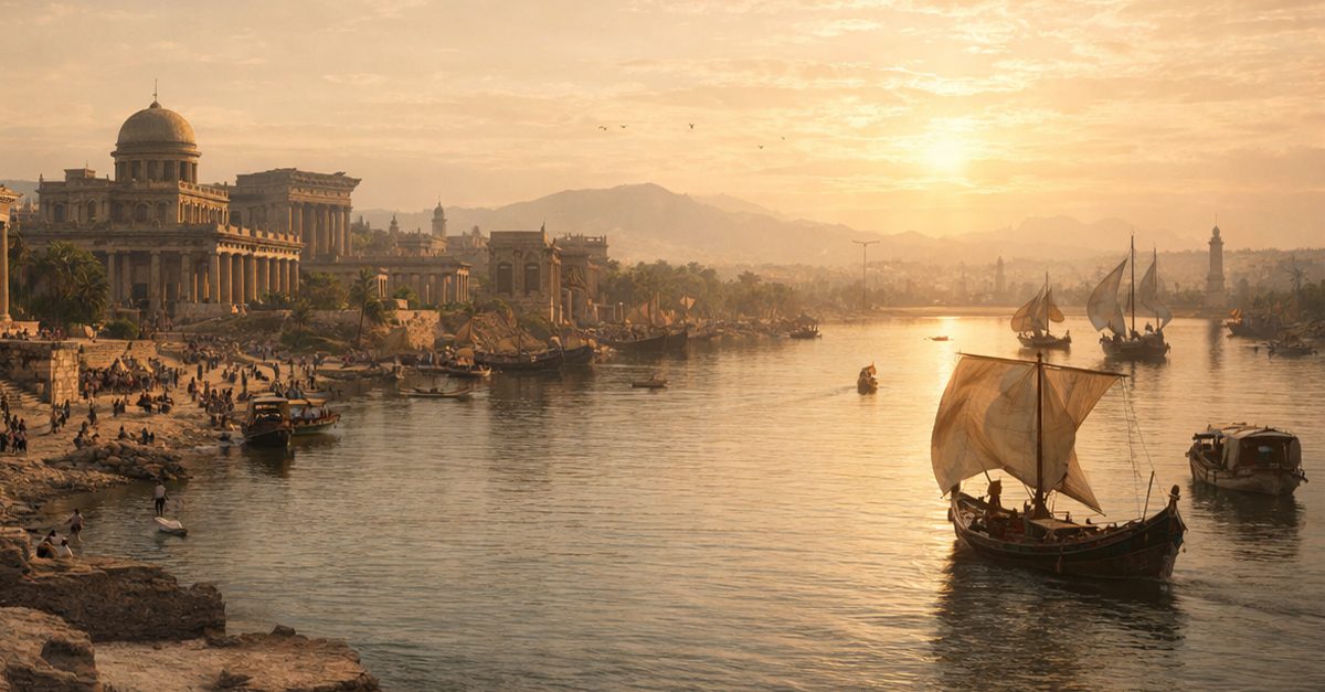
Life In A Global Trade Hub
For more than five centuries, the city existed as a bustling center where goods from distant lands converged. Spices and textiles from India, exotic woods, semi-precious stones, and possibly even Chinese silk all passed in splendor through this buzzing hub of hagglers before moving inland and across empires.

Connecting East And West
The location of Alexandria on the Tigris made the city a crucial connection point between East and West. Ships coming from the Persian Gulf could transfer their cargo to river transport bound for Seleucia, Ctesiphon, and beyond, making the city a crucial hub along the important ancient global trade networks.
 Alireza Shakernia, Wikimedia Commons
Evidence From Surface Finds
Thousands of pottery sherds, brick fragments, and industrial debris have been unearthed across the site, strongly suggesting extensive occupation and industry. The diversity of these finds points to a vibrant community involved in trade, craft, and daily life typical of a major Hellenistic metropolis.
 The Portable Antiquities Scheme, Faye Sayer, 2004-03-16 12:21:11, Wikimedia Commons
Decline Starts With Environmental Change
Over time, the Tigris River shifted westward and the Persian Gulf’s shoreline moved further away. By the third century AD, the city’s access to deepwater trade was greatly diminished, and with, its entire reason for existing. The loss of maritime access undermined Alexandria’s economic foundation and prompting gradual abandonment.

Forgotten Millennium
After this steep decline, Alexandria on the Tigris faded from the historical record. Written accounts were few and far between, and the city turned into not much more than a name in ancient texts, its monumental walls hidden under the swirling sand dunes that began to devour the surrounding landscape.

Rediscovery Reshapes History
Archaeologists are now coming to the realization that the city’s rediscovery greatly alters our understanding of Hellenistic and early Roman Near Eastern history. This is because we can now see that the ancient world had a far more interconnected global economy than we ever thought possible.

Gateway For Ancient Commodities
The city’s role in trade wasn’t just about the common bulk staple goods but also the highly prized luxury items. With the city’s dual access to river and sea routes, it channeled the exotic material culture of India and beyond to markets across Mesopotamia and into the Mediterranean world.
 AmanAgrahari01, Wikimedia Commons
Clash Of Rivers And Time
Ironically, the same natural forces that led to the city’s development eventually led to its decline. Geological changes, shifting rivers, and remorselessly advancing desertification cut off its lifelines and covered over its footprint, removing it from our collective memory.

Role Of Technology In Rediscovery
Without drones, magnetometers, and digital mapping techniques, the city sould still be lost. These modern technologies have allowed archaeologists to reconstruct hidden walls, canals, and district plans without having to do any of the destructive excavation that was the hallmark of archaeological work of previous eras.

Plans For Future Excavation
While security and funding challenges remain, scholars are determined to begin controlled excavations when the conditions are right for it. These digs could uncover buildings, artifacts, and further insights into the complex and fascinating daily life of this ancient trade capital.

Ancient Globalization
The rediscovery is another overhaul of our views of the ancient world, and proves to us that ancient globalization was a real process: economic, cultural, and technological networks once spanned continents. Alexandria on the Tigris is evidence not only of Alexander’s drive for conquest, but also of humanity’s longstanding interconnectedness.

A Hidden City Is A World Of Its Own
The rediscovery of Alexandria on the Tigris has revived a once-vital pivot of ancient global commerce for centuries. From its origins under Alexander the Great to its disappearance and eventual unearthing with modern technology, the story is another chapter on the story of how ancient cities could vanish and reemerge, forcing us to totally rewrite what we thought we knew about the ancient world.
 Carole Raddato from FRANKFURT, Germany, Wikimedia Commons
You May Also Like:
The Top Archaeological Discoveries Of 2024